
 Józefów nad Wisłą
Gorzyce Wielkie
Rogówek
Sromowce Niżne
Wyszków County
Kruszewo
Jantar
Sady Górne
Nagoszewo
Józefów nad Wisłą
Gorzyce Wielkie
Rogówek
Sromowce Niżne
Wyszków County
Kruszewo
Jantar
Sady Górne
Nagoszewo
Kościół Rzymskokatolicki Sanktuarium Matki Bożej Loretańskiej on the map, Wyszkow, Poland
Photo
Where is located Kościół Rzymskokatolicki Sanktuarium Matki Bożej Loretańskiej
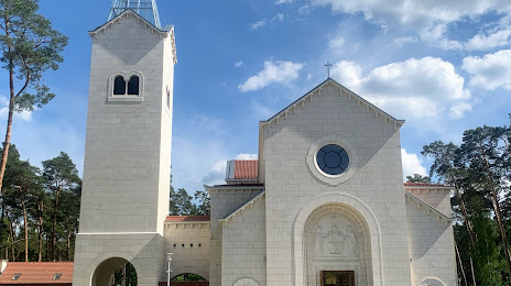
Kościół Rzymskokatolicki Sanktuarium Matki Bożej Loretańskiej — local attraction, which is located at 07-200 Loretto, Poland and belongs to the category — catholic church. Average visitor rating for this place — 4.5 (according to 110 ratings, information from open sources and relevant for 2022).
Exact location — Kościół Rzymskokatolicki Sanktuarium Matki Bożej Loretańskiej, marked on the map with a red marker.
You can get directions to Kościół Rzymskokatolicki Sanktuarium Matki Bożej Loretańskiej on the map from your location.
What else is interesting in Wyszkow? You can see all the sights if you go to the city page.
Coordinates
Kościół Rzymskokatolicki Sanktuarium Matki Bożej Loretańskiej, Poland coordinates in decimal format: latitude — 52.5729664377803, longitude — 21.58167652535882. When converted to degrees, minutes, seconds Kościół Rzymskokatolicki Sanktuarium Matki Bożej Loretańskiej has the following coordinates: 52°34′22.68 north latitude and 21°34′54.04 east longitude.
Nearby cities
The largest cities that are located nearby:
- Plock — 118 km
- Bialystok — 128 km
- Radom — 133 km
- Olsztyn — 146 km
- Wloclawek — 160 km
- Brest
 (Belarus) — 164 km
 - Łódź — 165 km
- Lublin — 168 km
- Torun — 196 km
- Kielce — 200 km
- Elblag — 218 km
- Bydgoszcz — 236 km
- Kaliningrad
 (Russia) — 242 km
 - Kalisz — 248 km
- Częstochowa — 256 km
- Gdańsk — 266 km
- Gdynia — 284 km
- Rzeszow — 285 km
- Tarnow — 287 km
Distance to the capital
Distance to the capital (Warsaw) is about — 54 km.