
 Józefów nad Wisłą
Gorzyce Wielkie
Rogówek
Sromowce Niżne
Wyszków County
Kruszewo
Jantar
Sady Górne
Nagoszewo
Józefów nad Wisłą
Gorzyce Wielkie
Rogówek
Sromowce Niżne
Wyszków County
Kruszewo
Jantar
Sady Górne
Nagoszewo
Muzeum w Tomaszowie Mazowieckim im. Antoniego hr. Ostrowskiego on the map, Tomaszow Mazowiecki, Poland
Photo
Where is located Muzeum w Tomaszowie Mazowieckim im. Antoniego hr. Ostrowskiego
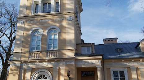
Muzeum w Tomaszowie Mazowieckim im. Antoniego hr. Ostrowskiego — local attraction, which is located at Pałac Ostrowskich, Polskiej Organizacji Wojskowej 11/15, 97-200 Tomaszów Mazowiecki, Poland and belongs to the category — museum. Average visitor rating for this place — 4.3 (according to 187 ratings, information from open sources and relevant for 2022).
Exact location — Muzeum w Tomaszowie Mazowieckim im. Antoniego hr. Ostrowskiego, marked on the map with a red marker.
You can get directions to Muzeum w Tomaszowie Mazowieckim im. Antoniego hr. Ostrowskiego on the map from your location.
What else is interesting in Tomaszow Mazowiecki? You can see all the sights if you go to the city page.
Coordinates
Muzeum w Tomaszowie Mazowieckim im. Antoniego hr. Ostrowskiego, Poland coordinates in decimal format: latitude — 51.531381545490156, longitude — 20.01231222532025. When converted to degrees, minutes, seconds Muzeum w Tomaszowie Mazowieckim im. Antoniego hr. Ostrowskiego has the following coordinates: 51°31′52.97 north latitude and 20°0′44.32 east longitude.
Nearby cities
The largest cities that are located nearby:
- Łódź — 45 km
- Radom — 80 km
- Kielce — 85 km
- Częstochowa — 101 km
- Plock — 114 km
- Kalisz — 134 km
- Wloclawek — 139 km
- Dabrowa Gornicza — 146 km
- Sosnowiec — 152 km
- Bytom — 152 km
- Chorzow — 155 km
- Katowice — 156 km
- Zabrze — 159 km
- Kraków — 162 km
- Ruda Slaska — 163 km
- Gliwice — 166 km
- Opole — 174 km
- Lublin — 180 km
- Tarnow — 182 km
Distance to the capital
Distance to the capital (Warsaw) is about — 104 km.