
 Józefów nad Wisłą
Gorzyce Wielkie
Rogówek
Sromowce Niżne
Wyszków County
Kruszewo
Jantar
Sady Górne
Nagoszewo
Józefów nad Wisłą
Gorzyce Wielkie
Rogówek
Sromowce Niżne
Wyszków County
Kruszewo
Jantar
Sady Górne
Nagoszewo
Sanktuarium Świętej Jadwigi Śląskiej on the map, Trzebnica, Poland
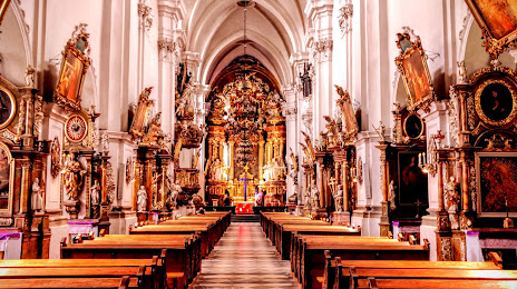
Photo
Where is located Sanktuarium Świętej Jadwigi Śląskiej
Sanktuarium Świętej Jadwigi Śląskiej — local attraction, which is located at Jana Pawła II 3, 55-100 Trzebnica, Poland and belongs to the category — abbey. Average visitor rating for this place — 4.7 (according to 1212 ratings, information from open sources and relevant for 2022).
Exact location — Sanktuarium Świętej Jadwigi Śląskiej, marked on the map with a red marker.
You can get directions to Sanktuarium Świętej Jadwigi Śląskiej on the map from your location.
What else is interesting in Trzebnica? You can see all the sights if you go to the city page.
Coordinates
Sanktuarium Świętej Jadwigi Śląskiej, Poland coordinates in decimal format: latitude — 51.30889119889416, longitude — 17.066964025312153. When converted to degrees, minutes, seconds Sanktuarium Świętej Jadwigi Śląskiej has the following coordinates: 51°18′32.01 north latitude and 17°4′1.07 east longitude.
Nearby cities
The largest cities that are located nearby:
- Wrocław — 22 km
- Legnica — 64 km
- Walbrzych — 80 km
- Kalisz — 86 km
- Opole — 92 km
- Poznań — 122 km
- Zielona Gora — 127 km
- Częstochowa — 154 km
- Gliwice — 160 km
- Zabrze — 163 km
- Bytom — 169 km
- Rybnik — 170 km
- Łódź — 171 km
- Ruda Slaska — 172 km
- Chorzow — 174 km
- Katowice — 180 km
- Sosnowiec — 183 km
- Ostrava
 (Czech Republic) — 186 km
 - Dabrowa Gornicza — 186 km
Distance to the capital
Distance to the capital (Warsaw) is about — 290 km.