
 Puerto de la Duquesa
La Serna de Iguña
Pumalverde
Puentenansa
La Iglesia
Casar de Periedo
Fuengirola
Renedo de Piélagos
Villabanez
Puerto de la Duquesa
La Serna de Iguña
Pumalverde
Puentenansa
La Iglesia
Casar de Periedo
Fuengirola
Renedo de Piélagos
Villabanez
Playa del Conde on the map, Pilar de la Horadada, Spain
Photo
Where is located Playa del Conde
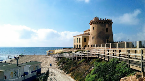
Playa del Conde — local attraction, which is located at Av. del Mediterraneo, 3, 03191 Pilar de la Horadada, Alicante, Spain and belongs to the category — super public bath. Average visitor rating for this place — 4.5 (according to 1189 ratings, information from open sources and relevant for 2022).
Exact location — Playa del Conde, marked on the map with a red marker.
You can get directions to Playa del Conde on the map from your location.
What else is interesting in Pilar de la Horadada? You can see all the sights if you go to the city page.
Coordinates
Playa del Conde, Spain coordinates in decimal format: latitude — 37.86927026705993, longitude — -0.7567064751302264. When converted to degrees, minutes, seconds Playa del Conde has the following coordinates: 37°52′9.37 north latitude and -0°45′24.14 east longitude.
Nearby cities
The largest cities that are located nearby:
- Cartagena — 32 km
- Murcia — 33 km
- Albacete — 155 km
- Valencia — 181 km
- Almería — 187 km
- Oran
 (Algeria) — 240 km
 - Granada — 259 km
- Jaén — 262 km
- Relizane (Algeria) — 264 km
- Chlef (Algeria) — 267 km
- Sidi Bel Abbes (Algeria) — 295 km
- Tlemcen (Algeria) — 333 km
- Saida (Algeria) — 345 km
- Málaga — 346 km
- Córdoba — 348 km
- Palma — 349 km
- Nador
 (Morocco) — 356 km
 - Algiers (Algeria) — 361 km
- Alcala de Henares — 361 km
Distance to the capital
Distance to the capital (Madrid) is about — 381 km.