
 Józefów nad Wisłą
Gorzyce Wielkie
Rogówek
Sromowce Niżne
Wyszków County
Kruszewo
Jantar
Sady Górne
Nagoszewo
Józefów nad Wisłą
Gorzyce Wielkie
Rogówek
Sromowce Niżne
Wyszków County
Kruszewo
Jantar
Sady Górne
Nagoszewo
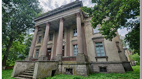
Pałac z 1906 roku Jana Turno on the map, Oborniki, Poland
Photo
Where is located Pałac z 1906 roku Jana Turno
Pałac z 1906 roku Jana Turno — local attraction, which is located at 1,, 64-610 Słomowo, Poland and belongs to the category — historical landmark. Average visitor rating for this place — 4.3 (according to 30 ratings, information from open sources and relevant for 2022).
Exact location — Pałac z 1906 roku Jana Turno, marked on the map with a red marker.
You can get directions to Pałac z 1906 roku Jana Turno on the map from your location.
What else is interesting in Oborniki? You can see all the sights if you go to the city page.
Coordinates
Pałac z 1906 roku Jana Turno, Poland coordinates in decimal format: latitude — 52.68665991393951, longitude — 16.95175842536311. When converted to degrees, minutes, seconds Pałac z 1906 roku Jana Turno has the following coordinates: 52°41′11.98 north latitude and 16°57′6.33 east longitude.
Nearby cities
The largest cities that are located nearby:
- Poznań — 27 km
- Bydgoszcz — 95 km
- Gorzów Wielkopolski — 106 km
- Zielona Gora — 119 km
- Torun — 126 km
- Kalisz — 130 km
- Wloclawek — 151 km
- Legnica — 165 km
- Wrocław — 171 km
- Szczecin — 172 km
- Koszalin — 176 km
- Plock — 195 km
- Cottbus
 (Germany) — 196 km
 - Łódź — 206 km
- Walbrzych — 209 km
- Gdańsk — 223 km
- Berlin (Germany) — 230 km
- Berlin (Germany) — 231 km
- Opole — 231 km
Distance to the capital
Distance to the capital (Warsaw) is about — 280 km.