
 Gilserberg
Berlin
Bordesholm
Bechtolsheim
Aub
Triptis
Heppenheim
Biblis
Angermünde
Gilserberg
Berlin
Bordesholm
Bechtolsheim
Aub
Triptis
Heppenheim
Biblis
Angermünde
Wardersee on the map, Bad Segeberg, Germany
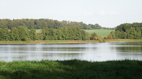
Photo
Where is located Wardersee
Wardersee — local attraction, which is located at 3.6 km² and belongs to the category — -. Average visitor rating for this place — 4.7 (according to 18 ratings, information from open sources and relevant for 2022).
Exact location — Wardersee, marked on the map with a red marker.
You can get directions to Wardersee on the map from your location.
What else is interesting in Bad Segeberg? You can see all the sights if you go to the city page.
Coordinates
Wardersee, Germany coordinates in decimal format: latitude — 53.97038285032344, longitude — 10.406517760264757. When converted to degrees, minutes, seconds Wardersee has the following coordinates: 53°58′13.38 north latitude and 10°24′23.46 east longitude.
Nearby cities
The largest cities that are located nearby:
- Kiel — 44 km
- Rostock — 118 km
- Bremerhaven — 122 km
- Bremen — 138 km
- Odense
 (Denmark) — 162 km
 - Wolfsburg — 171 km
- Hanover — 177 km
- Brunswick — 185 km
- Salzgitter — 198 km
- Hildesheim — 199 km
- Magdeburg — 220 km
- Copenhagen (Denmark) — 238 km
- Osnabrück — 239 km
- Bielefeld — 243 km
- Aarhus (Denmark) — 246 km
- Malmö
 (Sweden) — 250 km
 - Potsdam — 253 km
- Groningen
 (Netherlands) — 260 km
 - Emmen (Netherlands) — 261 km
Distance to the capital
Distance to the capital (Berlin) is about — 257 km.