
 Gilserberg
Berlin
Bordesholm
Bechtolsheim
Aub
Triptis
Heppenheim
Biblis
Angermünde
Gilserberg
Berlin
Bordesholm
Bechtolsheim
Aub
Triptis
Heppenheim
Biblis
Angermünde
Frohnauer Hammer on the map, Annaberg-Buchholz, Germany
Photo
Where is located Frohnauer Hammer
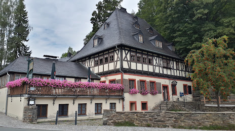
Frohnauer Hammer — local attraction, which is located at Sehmatalstraße 3, 09456 Annaberg-Buchholz, Germany and belongs to the category — museum. Average visitor rating for this place — 4.6 (according to 956 ratings, information from open sources and relevant for 2022).
Exact location — Frohnauer Hammer, marked on the map with a red marker.
You can get directions to Frohnauer Hammer on the map from your location.
What else is interesting in Annaberg-Buchholz? You can see all the sights if you go to the city page.
Coordinates
Frohnauer Hammer, Germany coordinates in decimal format: latitude — 50.581681722939784, longitude — 12.995575725285601. When converted to degrees, minutes, seconds Frohnauer Hammer has the following coordinates: 50°34′54.05 north latitude and 12°59′44.07 east longitude.
Nearby cities
The largest cities that are located nearby:
- Chemnitz — 28 km
- Dresden — 73 km
- Gera — 73 km
- Leipzig — 95 km
- Pilsen
 (Czech Republic) — 97 km
 - Prague (Czech Republic) — 116 km
- Erfurt — 145 km
- Cottbus — 159 km
- Erlangen — 180 km
- Regensburg — 185 km
- Nuremberg — 186 km
- Fürth — 189 km
- Magdeburg — 195 km
- Potsdam — 200 km
- Berlin — 214 km
- Zielona Gora
 (Poland) — 227 km
 - Legnica (Poland) — 229 km
- Walbrzych (Poland) — 230 km
- Ingolstadt — 231 km
Distance to the capital
Distance to the capital (Berlin) is about — 217 km.