
 Józefów nad Wisłą
Gorzyce Wielkie
Rogówek
Sromowce Niżne
Wyszków County
Kruszewo
Jantar
Sady Górne
Nagoszewo
Józefów nad Wisłą
Gorzyce Wielkie
Rogówek
Sromowce Niżne
Wyszków County
Kruszewo
Jantar
Sady Górne
Nagoszewo
Izba Historii Kanału Elbląskiego on the map, Pasłęk, Poland
Photo
Where is located Izba Historii Kanału Elbląskiego
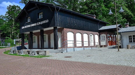
Izba Historii Kanału Elbląskiego — local attraction, which is located at 14-400 Pasłęk, Poland and belongs to the category — museum. Average visitor rating for this place — 4.5 (according to 44 ratings, information from open sources and relevant for 2022).
Exact location — Izba Historii Kanału Elbląskiego, marked on the map with a red marker.
You can get directions to Izba Historii Kanału Elbląskiego on the map from your location.
What else is interesting in Pasłęk? You can see all the sights if you go to the city page.
Coordinates
Izba Historii Kanału Elbląskiego, Poland coordinates in decimal format: latitude — 53.97764178675443, longitude — 19.61866492541177. When converted to degrees, minutes, seconds Izba Historii Kanału Elbląskiego has the following coordinates: 53°58′39.51 north latitude and 19°37′7.19 east longitude.
Nearby cities
The largest cities that are located nearby:
- Elblag — 20 km
- Olsztyn — 62 km
- Gdańsk — 73 km
- Gdynia — 89 km
- Kaliningrad
 (Russia) — 91 km
 - Torun — 136 km
- Bydgoszcz — 151 km
- Wloclawek — 161 km
- Plock — 168 km
- Klaipėda
 (Lithuania) — 204 km
 - Koszalin — 226 km
- Bialystok — 254 km
- Łódź — 255 km
- Poznań — 260 km
- Kalisz — 276 km
- Kaunas (Lithuania) — 285 km
- Šiauliai (Lithuania) — 307 km
- Radom — 311 km
- Gorzów Wielkopolski — 331 km
Distance to the capital
Distance to the capital (Warsaw) is about — 216 km.