
 Gilserberg
Berlin
Bordesholm
Bechtolsheim
Aub
Triptis
Heppenheim
Biblis
Angermünde
Gilserberg
Berlin
Bordesholm
Bechtolsheim
Aub
Triptis
Heppenheim
Biblis
Angermünde
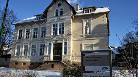
LWL-Archäologie für Westfalen on the map, Olpe, Germany
Photo
Where is located LWL-Archäologie für Westfalen
LWL-Archäologie für Westfalen — local attraction, which is located at In der Wüste 4, 57462 Olpe, Germany and belongs to the category — museum. Average visitor rating for this place — 4.4 (according to 5 ratings, information from open sources and relevant for 2022).
Exact location — LWL-Archäologie für Westfalen, marked on the map with a red marker.
You can get directions to LWL-Archäologie für Westfalen on the map from your location.
What else is interesting in Olpe? You can see all the sights if you go to the city page.
Coordinates
LWL-Archäologie für Westfalen, Germany coordinates in decimal format: latitude — 51.03071181624745, longitude — 7.843096725301956. When converted to degrees, minutes, seconds LWL-Archäologie für Westfalen has the following coordinates: 51°1′50.56 north latitude and 7°50′35.15 east longitude.
Nearby cities
The largest cities that are located nearby:
- Siegen — 20 km
- Hagen — 46 km
- Remscheid — 49 km
- Bergisch Gladbach — 50 km
- Wuppertal — 55 km
- Solingen — 55 km
- Witten — 57 km
- Dortmund — 60 km
- Bonn — 62 km
- Cologne — 63 km
- Bochum — 66 km
- Hamm — 71 km
- Herne — 72 km
- Essen — 75 km
- Gelsenkirchen — 75 km
- Koblenz — 76 km
- Düsseldorf — 78 km
- Recklinghausen — 79 km
- Mülheim — 79 km
Distance to the capital
Distance to the capital (Berlin) is about — 417 km.