
 Puerto de la Duquesa
La Serna de Iguña
Pumalverde
Puentenansa
La Iglesia
Casar de Periedo
Fuengirola
Renedo de Piélagos
Villabanez
Puerto de la Duquesa
La Serna de Iguña
Pumalverde
Puentenansa
La Iglesia
Casar de Periedo
Fuengirola
Renedo de Piélagos
Villabanez
Yacimiento Arqueológico Romano Carteia on the map, La Linea de la Concepción, Spain
Photo
Where is located Yacimiento Arqueológico Romano Carteia
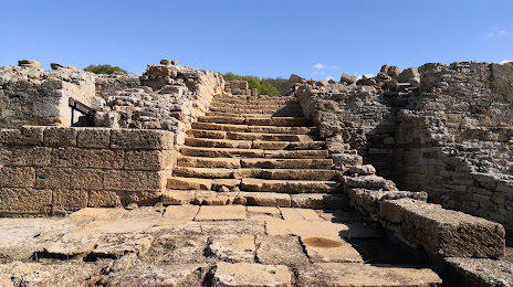
Yacimiento Arqueológico Romano Carteia — local attraction, which is located at 11369, Cádiz, Spain and belongs to the category — archaeological site. Average visitor rating for this place — 4.4 (according to 177 ratings, information from open sources and relevant for 2022).
Exact location — Yacimiento Arqueológico Romano Carteia, marked on the map with a red marker.
You can get directions to Yacimiento Arqueológico Romano Carteia on the map from your location.
What else is interesting in La Linea de la Concepción? You can see all the sights if you go to the city page.
Coordinates
Yacimiento Arqueológico Romano Carteia, Spain coordinates in decimal format: latitude — 36.185938813241506, longitude — -5.406471275177848. When converted to degrees, minutes, seconds Yacimiento Arqueológico Romano Carteia has the following coordinates: 36°11′9.38 north latitude and -5°24′23.3 east longitude.
Nearby cities
The largest cities that are located nearby:
- Algeciras — 10 km
- Marbella — 56 km
- Tangier
 (Morocco) — 63 km
 - Tetouan (Morocco) — 67 km
- Jerez — 89 km
- Cádiz — 92 km
- Málaga — 95 km
- Dos Hermanas — 134 km
- Huelva — 185 km
- Granada — 190 km
- Taounate (Morocco) — 192 km
- Córdoba — 197 km
- Jaén — 225 km
- Kenitra (Morocco) — 240 km
- Nador (Morocco) — 245 km
- Taza (Morocco) — 248 km
- Meknes (Morocco) — 252 km
- Almería — 266 km
- Khemisset (Morocco) — 268 km
Distance to the capital
Distance to the capital (Madrid) is about — 493 km.