
 Józefów nad Wisłą
Gorzyce Wielkie
Rogówek
Sromowce Niżne
Wyszków County
Kruszewo
Jantar
Sady Górne
Nagoszewo
Józefów nad Wisłą
Gorzyce Wielkie
Rogówek
Sromowce Niżne
Wyszków County
Kruszewo
Jantar
Sady Górne
Nagoszewo
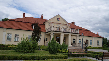
Museum of the Leżajsk land on the map, Leżajsk, Poland
Photo
Where is located Museum of the Leżajsk land
Museum of the Leżajsk land — local attraction, which is located at Adama Mickiewicza 20, 37-300 Leżajsk, Poland and belongs to the category — museum. Average visitor rating for this place — 4.5 (according to 254 ratings, information from open sources and relevant for 2022).
Exact location — Museum of the Leżajsk land, marked on the map with a red marker.
You can get directions to Museum of the Leżajsk land on the map from your location.
What else is interesting in Leżajsk? You can see all the sights if you go to the city page.
Coordinates
Museum of the Leżajsk land, Poland coordinates in decimal format: latitude — 50.25507011078129, longitude — 22.422913325273736. When converted to degrees, minutes, seconds Museum of the Leżajsk land has the following coordinates: 50°15′18.25 north latitude and 22°25′22.49 east longitude.
Nearby cities
The largest cities that are located nearby:
- Rzeszow — 39 km
- Tarnow — 106 km
- Lublin — 109 km
- Kielce — 142 km
- Radom — 154 km
- Kraków — 177 km
- Uzhhorod
 (Ukraine) — 182 km
 - Košice
 (Slovakia) — 190 km
 - Brest
 (Belarus) — 222 km
 - Dabrowa Gornicza — 228 km
- Sosnowiec — 234 km
- Częstochowa — 238 km
- Katowice — 240 km
- Bielsko-Biala — 245 km
- Chorzow — 245 km
- Bytom — 248 km
- Ruda Slaska — 252 km
- Zabrze — 257 km
- Nyíregyháza
 (Hungary) — 261 km
Distance to the capital
Distance to the capital (Warsaw) is about — 241 km.