
 Józefów nad Wisłą
Gorzyce Wielkie
Rogówek
Sromowce Niżne
Wyszków County
Kruszewo
Jantar
Sady Górne
Nagoszewo
Józefów nad Wisłą
Gorzyce Wielkie
Rogówek
Sromowce Niżne
Wyszków County
Kruszewo
Jantar
Sady Górne
Nagoszewo
Rudnik on the map, Kowary, Poland
Photo
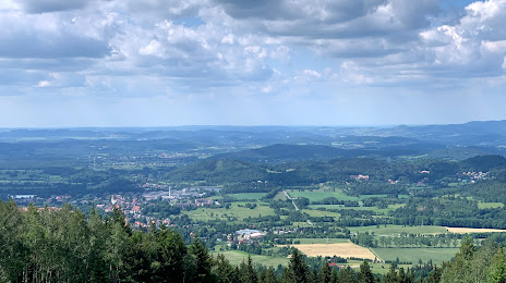
Where is located Rudnik
Rudnik — local attraction, which is located at 58-530, Kowary, Poland and belongs to the category — scenic spot. Average visitor rating for this place — 4.7 (according to 62 ratings, information from open sources and relevant for 2022).
Exact location — Rudnik, marked on the map with a red marker.
You can get directions to Rudnik on the map from your location.
What else is interesting in Kowary? You can see all the sights if you go to the city page.
Coordinates
Rudnik, Poland coordinates in decimal format: latitude — 50.7592563387073, longitude — 15.840131325292033. When converted to degrees, minutes, seconds Rudnik has the following coordinates: 50°45′33.32 north latitude and 15°50′24.47 east longitude.
Nearby cities
The largest cities that are located nearby:
- Walbrzych — 31 km
- Legnica — 51 km
- Wrocław — 90 km
- Prague
 (Czech Republic) — 127 km
 - Zielona Gora — 128 km
- Opole — 147 km
- Cottbus
 (Germany) — 148 km
 - Dresden (Germany) — 149 km
- Olomouc (Czech Republic) — 167 km
- Brno (Czech Republic) — 185 km
- Kalisz — 188 km
- Poznań — 193 km
- Ostrava (Czech Republic) — 204 km
- Chemnitz (Germany) — 204 km
- Rybnik — 207 km
- Gliwice — 208 km
- Pilsen (Czech Republic) — 211 km
- Zabrze — 214 km
- Gorzów Wielkopolski — 218 km
Distance to the capital
Distance to the capital (Warsaw) is about — 394 km.