
 Józefów nad Wisłą
Gorzyce Wielkie
Rogówek
Sromowce Niżne
Wyszków County
Kruszewo
Jantar
Sady Górne
Nagoszewo
Józefów nad Wisłą
Gorzyce Wielkie
Rogówek
Sromowce Niżne
Wyszków County
Kruszewo
Jantar
Sady Górne
Nagoszewo
Las Młochowski on the map, Brwinów, Poland
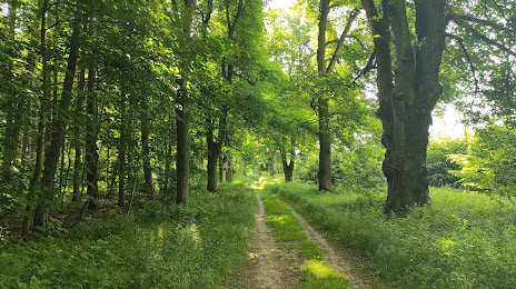
Photo
Where is located Las Młochowski
Las Młochowski — local attraction, which is located at 05-807 Podkowa Lesna, Poland and belongs to the category — national forest. Average visitor rating for this place — 4.6 (according to 979 ratings, information from open sources and relevant for 2022).
Exact location — Las Młochowski, marked on the map with a red marker.
You can get directions to Las Młochowski on the map from your location.
What else is interesting in Brwinów? You can see all the sights if you go to the city page.
Coordinates
Las Młochowski, Poland coordinates in decimal format: latitude — 52.034034691950986, longitude — 20.762807810268. When converted to degrees, minutes, seconds Las Młochowski has the following coordinates: 52°2′2.52 north latitude and 20°45′46.11 east longitude.
Nearby cities
The largest cities that are located nearby:
- Plock — 81 km
- Radom — 87 km
- Łódź — 96 km
- Wloclawek — 124 km
- Kielce — 141 km
- Lublin — 162 km
- Torun — 171 km
- Olsztyn — 182 km
- Częstochowa — 185 km
- Kalisz — 185 km
- Bialystok — 196 km
- Brest
 (Belarus) — 205 km
 - Bydgoszcz — 210 km
- Dabrowa Gornicza — 228 km
- Sosnowiec — 235 km
- Bytom — 236 km
- Kraków — 236 km
- Tarnow — 236 km
- Elblag — 238 km
Distance to the capital
Distance to the capital (Warsaw) is about — 28 km.