
 زفتى
Qesm Hurghada
Gazirat Muhammad
Qesm Nakhl
Om Sabir Village
6th of October City
Cairo Governorate
Qism Sidi Gabir
Ezbet Hussein Salamah
زفتى
Qesm Hurghada
Gazirat Muhammad
Qesm Nakhl
Om Sabir Village
6th of October City
Cairo Governorate
Qism Sidi Gabir
Ezbet Hussein Salamah
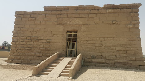
Deir el-Shelwit Temple on the map, Luxor, Egypt
Photo
Where is located Deir el-Shelwit Temple
Deir el-Shelwit Temple — local attraction, which is located at MHWH+3CJ, Ad Dabaeyah, Al Qarna, Luxor Governorate, Egypt and belongs to the category — museum. Average visitor rating for this place — 4.6 (according to 41 rating, information from open sources and relevant for 2022).
Exact location — Deir el-Shelwit Temple, marked on the map with a red marker.
You can get directions to Deir el-Shelwit Temple on the map from your location.
What else is interesting in Luxor? You can see all the sights if you go to the city page.
Coordinates
Deir el-Shelwit Temple, Egypt coordinates in decimal format: latitude — 25.695173778128073, longitude — 32.57843662456895. When converted to degrees, minutes, seconds Deir el-Shelwit Temple has the following coordinates: 25°41′42.63 north latitude and 32°34′42.37 east longitude.
Nearby cities
The largest cities that are located nearby:
- Qena — 52 km
- Sohag — 134 km
- Aswan — 179 km
- Asyut — 218 km
- Mallawi — 287 km
- Beni Suef — 402 km
- Suez — 473 km
- Tabuk
 (Saudi Arabia) — 486 km
 - Qalyub — 515 km
- Ismailia — 544 km
- Banha — 546 km
- Zagazig — 551 km
- Talkha — 605 km
- Port Said — 618 km
- Idku — 659 km
- Alexandria — 662 km
- Ashqelon
 (Israel) — 686 km
 - Ashdod (Israel) — 702 km
- Medina (Saudi Arabia) — 713 km
Distance to the capital
Distance to the capital (Cairo) is about — 501 km.