
 Gilserberg
Berlin
Bordesholm
Bechtolsheim
Aub
Triptis
Heppenheim
Biblis
Angermünde
Gilserberg
Berlin
Bordesholm
Bechtolsheim
Aub
Triptis
Heppenheim
Biblis
Angermünde
Sielmanns Naturlandschaft Kyritz-Ruppiner Heide on the map, Wittstock, Germany
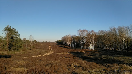
Photo
Where is located Sielmanns Naturlandschaft Kyritz-Ruppiner Heide
Sielmanns Naturlandschaft Kyritz-Ruppiner Heide — local attraction, which is located at Unnamed Road,, 16818 Temnitzquell, Germany and belongs to the category — national reserve. Average visitor rating for this place — 4.6 (according to 35 ratings, information from open sources and relevant for 2022).
Exact location — Sielmanns Naturlandschaft Kyritz-Ruppiner Heide, marked on the map with a red marker.
You can get directions to Sielmanns Naturlandschaft Kyritz-Ruppiner Heide on the map from your location.
What else is interesting in Wittstock? You can see all the sights if you go to the city page.
Coordinates
Sielmanns Naturlandschaft Kyritz-Ruppiner Heide, Germany coordinates in decimal format: latitude — 53.06554616857444, longitude — 12.65281682537733. When converted to degrees, minutes, seconds Sielmanns Naturlandschaft Kyritz-Ruppiner Heide has the following coordinates: 53°3′55.97 north latitude and 12°39′10.14 east longitude.
Nearby cities
The largest cities that are located nearby:
- Potsdam — 94 km
- Berlin — 96 km
- Rostock — 106 km
- Magdeburg — 129 km
- Szczecin
 (Poland) — 139 km
 - Wolfsburg — 141 km
- Brunswick — 165 km
- Salzgitter — 184 km
- Gorzów Wielkopolski (Poland) — 190 km
- Kiel — 199 km
- Cottbus — 200 km
- Leipzig — 202 km
- Hildesheim — 205 km
- Hanover — 205 km
- Bremen — 245 km
- Zielona Gora (Poland) — 247 km
- Dresden — 249 km
- Göttingen — 252 km
- Gera — 253 km
Distance to the capital
Distance to the capital (Berlin) is about — 79 km.