
 Puerto de la Duquesa
La Serna de Iguña
Pumalverde
Puentenansa
La Iglesia
Casar de Periedo
Fuengirola
Renedo de Piélagos
Villabanez
Puerto de la Duquesa
La Serna de Iguña
Pumalverde
Puentenansa
La Iglesia
Casar de Periedo
Fuengirola
Renedo de Piélagos
Villabanez
Castillo de Torredonjimeno on the map, Torredonjimeno, Spain
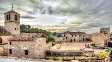
Photo
Where is located Castillo de Torredonjimeno
Castillo de Torredonjimeno — local attraction, which is located at C. Cantera, 1, 23650 Torredonjimeno, Jaén, Spain and belongs to the category — castle. Average visitor rating for this place — 4.3 (according to 67 ratings, information from open sources and relevant for 2022).
Exact location — Castillo de Torredonjimeno, marked on the map with a red marker.
You can get directions to Castillo de Torredonjimeno on the map from your location.
What else is interesting in Torredonjimeno? You can see all the sights if you go to the city page.
Coordinates
Castillo de Torredonjimeno, Spain coordinates in decimal format: latitude — 37.76553207500299, longitude — -3.9533166201196157. When converted to degrees, minutes, seconds Castillo de Torredonjimeno has the following coordinates: 37°45′55.92 north latitude and -3°57′11.94 east longitude.
Nearby cities
The largest cities that are located nearby:
- Jaén — 15 km
- Granada — 72 km
- Córdoba — 73 km
- Málaga — 123 km
- Marbella — 162 km
- Almería — 167 km
- Dos Hermanas — 181 km
- Algeciras — 224 km
- Albacete — 226 km
- Jerez — 227 km
- Murcia — 247 km
- Cádiz — 249 km
- Cartagena — 260 km
- Huelva — 269 km
- Tetouan
 (Morocco) — 274 km
 - Tangier (Morocco) — 279 km
- Fuenlabrada — 279 km
- Getafe — 282 km
- Móstoles — 283 km
Distance to the capital
Distance to the capital (Madrid) is about — 296 km.