
 Puerto de la Duquesa
La Serna de Iguña
Pumalverde
Puentenansa
La Iglesia
Casar de Periedo
Fuengirola
Renedo de Piélagos
Villabanez
Puerto de la Duquesa
La Serna de Iguña
Pumalverde
Puentenansa
La Iglesia
Casar de Periedo
Fuengirola
Renedo de Piélagos
Villabanez
Museo de Calatayud on the map, Calatayud, Spain
Photo
Where is located Museo de Calatayud
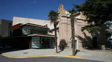
Museo de Calatayud — local attraction, which is located at Plaza Santa Teresa, 3, 50300 Calatayud, Zaragoza, Spain and belongs to the category — museum. Average visitor rating for this place — 4.3 (according to 207 ratings, information from open sources and relevant for 2022).
Exact location — Museo de Calatayud, marked on the map with a red marker.
You can get directions to Museo de Calatayud on the map from your location.
What else is interesting in Calatayud? You can see all the sights if you go to the city page.
Coordinates
Museo de Calatayud, Spain coordinates in decimal format: latitude — 41.35274443777336, longitude — -1.6471376750258615. When converted to degrees, minutes, seconds Museo de Calatayud has the following coordinates: 41°21′9.88 north latitude and -1°38′49.7 east longitude.
Nearby cities
The largest cities that are located nearby:
- Zaragoza — 71 km
- Logroño — 139 km
- Pamplona — 161 km
- Alcala de Henares — 174 km
- Torrejón de Ardoz — 183 km
- Vitoria-Gasteiz — 186 km
- Lleida — 190 km
- Alcobendas — 190 km
- Burgos — 200 km
- Getafe — 210 km
- Leganés — 211 km
- Alcorcón — 215 km
- Fuenlabrada — 217 km
- San Sebastián — 219 km
- Móstoles — 219 km
- Valencia — 235 km
- Bilbao — 235 km
- Tarragona — 242 km
- Valladolid — 256 km
Distance to the capital
Distance to the capital (Madrid) is about — 202 km.