
 Puerto de la Duquesa
La Serna de Iguña
Pumalverde
Puentenansa
La Iglesia
Casar de Periedo
Fuengirola
Renedo de Piélagos
Villabanez
Puerto de la Duquesa
La Serna de Iguña
Pumalverde
Puentenansa
La Iglesia
Casar de Periedo
Fuengirola
Renedo de Piélagos
Villabanez
Murallas de Ciudad Rodrigo on the map, Ciudad Rodrigo, Spain
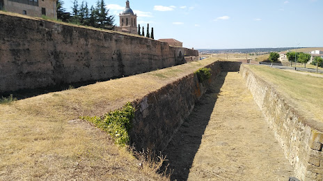
Photo
Where is located Murallas de Ciudad Rodrigo
Murallas de Ciudad Rodrigo — local attraction, which is located at C. Feliciano de Silva, 4, 37500 Cdad. Rodrigo, Salamanca, Spain and belongs to the category — fortress. Average visitor rating for this place — 4.8 (according to 126 ratings, information from open sources and relevant for 2022).
Exact location — Murallas de Ciudad Rodrigo, marked on the map with a red marker.
You can get directions to Murallas de Ciudad Rodrigo on the map from your location.
What else is interesting in Ciudad Rodrigo? You can see all the sights if you go to the city page.
Coordinates
Murallas de Ciudad Rodrigo, Spain coordinates in decimal format: latitude — 40.59800542082333, longitude — -6.537292475049123. When converted to degrees, minutes, seconds Murallas de Ciudad Rodrigo has the following coordinates: 40°35′52.82 north latitude and -6°32′14.25 east longitude.
Nearby cities
The largest cities that are located nearby:
- Salamanca — 83 km
- Coimbra
 (Portugal) — 164 km
 - Porto (Portugal) — 185 km
- Braga (Portugal) — 188 km
- Valladolid — 189 km
- Badajoz — 194 km
- Ourense — 221 km
- Móstoles — 227 km
- Alcorcón — 230 km
- Fuenlabrada — 233 km
- León — 235 km
- Leganés — 235 km
- Getafe — 238 km
- Alcobendas — 243 km
- Vigo — 255 km
- Torrejón de Ardoz — 258 km
- Alcala de Henares — 267 km
- Burgos — 302 km
- Lisbon (Portugal) — 306 km
Distance to the capital
Distance to the capital (Madrid) is about — 240 km.