
 Puerto de la Duquesa
La Serna de Iguña
Pumalverde
Puentenansa
La Iglesia
Casar de Periedo
Fuengirola
Renedo de Piélagos
Villabanez
Puerto de la Duquesa
La Serna de Iguña
Pumalverde
Puentenansa
La Iglesia
Casar de Periedo
Fuengirola
Renedo de Piélagos
Villabanez
Ermita de Chamorro on the map, Fene, Spain
Photo
Where is located Ermita de Chamorro
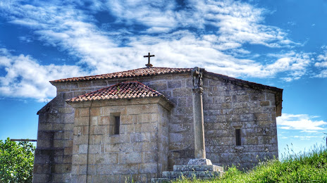
Ermita de Chamorro — local attraction, which is located at CP-3601, 299, 15595 Ferrol, A Coruña, Spain and belongs to the category — chapel. Average visitor rating for this place — 4.6 (according to 275 ratings, information from open sources and relevant for 2022).
Exact location — Ermita de Chamorro, marked on the map with a red marker.
You can get directions to Ermita de Chamorro on the map from your location.
What else is interesting in Fene? You can see all the sights if you go to the city page.
Coordinates
Ermita de Chamorro, Spain coordinates in decimal format: latitude — 43.50769236269738, longitude — -8.245384874957526. When converted to degrees, minutes, seconds Ermita de Chamorro has the following coordinates: 43°30′27.69 north latitude and -8°14′43.39 east longitude.
Nearby cities
The largest cities that are located nearby:
- A Coruña — 23 km
- Ourense — 128 km
- Vigo — 144 km
- Oviedo — 187 km
- Gijón — 201 km
- Braga
 (Portugal) — 214 km
 - León — 233 km
- Porto (Portugal) — 259 km
- Salamanca — 347 km
- Valladolid — 349 km
- Santander — 350 km
- Coimbra (Portugal) — 362 km
- Burgos — 386 km
- Bilbao — 422 km
- Vitoria-Gasteiz — 450 km
- Logroño — 480 km
- San Sebastián — 498 km
- Alcobendas — 500 km
- Móstoles — 503 km
Distance to the capital
Distance to the capital (Madrid) is about — 509 km.