
 Puerto de la Duquesa
La Serna de Iguña
Pumalverde
Puentenansa
La Iglesia
Casar de Periedo
Fuengirola
Renedo de Piélagos
Villabanez
Puerto de la Duquesa
La Serna de Iguña
Pumalverde
Puentenansa
La Iglesia
Casar de Periedo
Fuengirola
Renedo de Piélagos
Villabanez
Dolmen de Matarrubilla on the map, Tomares, Spain
Photo
Where is located Dolmen de Matarrubilla
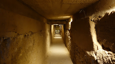
Dolmen de Matarrubilla — local attraction, which is located at 41907 Valencina de la Concepción, Seville, Spain and belongs to the category — historical landmark. Average visitor rating for this place — 4.4 (according to 57 ratings, information from open sources and relevant for 2022).
Exact location — Dolmen de Matarrubilla, marked on the map with a red marker.
You can get directions to Dolmen de Matarrubilla on the map from your location.
What else is interesting in Tomares? You can see all the sights if you go to the city page.
Coordinates
Dolmen de Matarrubilla, Spain coordinates in decimal format: latitude — 37.40545142848002, longitude — -6.06976457514351. When converted to degrees, minutes, seconds Dolmen de Matarrubilla has the following coordinates: 37°24′19.63 north latitude and -6°4′11.15 east longitude.
Nearby cities
The largest cities that are located nearby:
- Dos Hermanas — 15 km
- Jerez — 77 km
- Huelva — 80 km
- Cádiz — 96 km
- Córdoba — 124 km
- Marbella — 141 km
- Algeciras — 146 km
- Málaga — 159 km
- Tangier
 (Morocco) — 180 km
 - Badajoz — 184 km
- Jaén — 202 km
- Tetouan (Morocco) — 209 km
- Granada — 217 km
- Lisbon
 (Portugal) — 306 km
 - Amadora (Portugal) — 314 km
- Queluz (Portugal) — 316 km
- Almería — 323 km
- Taounate (Morocco) — 339 km
- Kenitra (Morocco) — 349 km
Distance to the capital
Distance to the capital (Madrid) is about — 393 km.