
 Puerto de la Duquesa
La Serna de Iguña
Pumalverde
Puentenansa
La Iglesia
Casar de Periedo
Fuengirola
Renedo de Piélagos
Villabanez
Puerto de la Duquesa
La Serna de Iguña
Pumalverde
Puentenansa
La Iglesia
Casar de Periedo
Fuengirola
Renedo de Piélagos
Villabanez
Parque Municipal San Vicente on the map, La Pobla de Vallbona, Spain
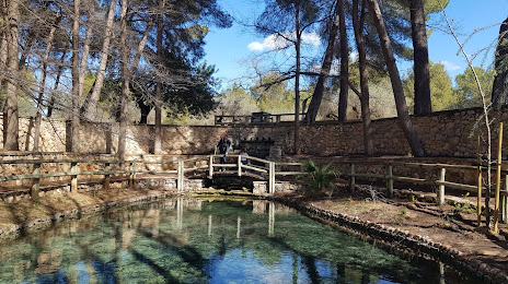
Photo
Where is located Parque Municipal San Vicente
Parque Municipal San Vicente — local attraction, which is located at C. 5, 25, Km. 2,5, 46160 Llíria, Valencia, Spain and belongs to the category — park. Average visitor rating for this place — 4.6 (according to 2421 rating, information from open sources and relevant for 2022).
Exact location — Parque Municipal San Vicente, marked on the map with a red marker.
You can get directions to Parque Municipal San Vicente on the map from your location.
What else is interesting in La Pobla de Vallbona? You can see all the sights if you go to the city page.
Coordinates
Parque Municipal San Vicente, Spain coordinates in decimal format: latitude — 39.65206210725483, longitude — -0.5754105750777841. When converted to degrees, minutes, seconds Parque Municipal San Vicente has the following coordinates: 39°39′7.42 north latitude and -0°34′31.48 east longitude.
Nearby cities
The largest cities that are located nearby:
- Valencia — 20 km
- Albacete — 131 km
- Murcia — 184 km
- Cartagena — 221 km
- Tarragona — 225 km
- Zaragoza — 229 km
- Lleida — 244 km
- Alcala de Henares — 256 km
- Torrejón de Ardoz — 264 km
- Palma — 273 km
- Alcobendas — 279 km
- Getafe — 279 km
- Leganés — 283 km
- Fuenlabrada — 285 km
- Alcorcón — 288 km
- Móstoles — 291 km
- L'Hospitalet de Llobregat — 295 km
- Terrassa — 304 km
- Santa Coloma de Gramenet — 307 km
Distance to the capital
Distance to the capital (Madrid) is about — 280 km.