
 Puerto de la Duquesa
La Serna de Iguña
Pumalverde
Puentenansa
La Iglesia
Casar de Periedo
Fuengirola
Renedo de Piélagos
Villabanez
Puerto de la Duquesa
La Serna de Iguña
Pumalverde
Puentenansa
La Iglesia
Casar de Periedo
Fuengirola
Renedo de Piélagos
Villabanez
Playa de Mata Negra on the map, Punta Umbría, Spain
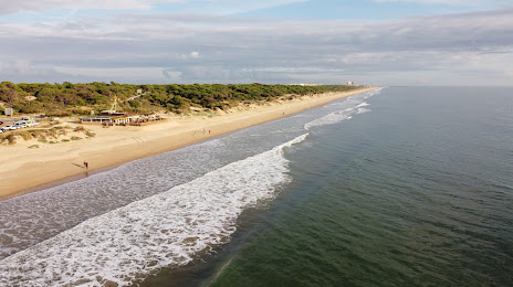
Photo
Where is located Playa de Mata Negra
Playa de Mata Negra — local attraction, which is located at Huelva and belongs to the category — -. Average visitor rating for this place — 4.4 (according to 55 ratings, information from open sources and relevant for 2022).
Exact location — Playa de Mata Negra, marked on the map with a red marker.
You can get directions to Playa de Mata Negra on the map from your location.
What else is interesting in Punta Umbría? You can see all the sights if you go to the city page.
Coordinates
Playa de Mata Negra, Spain coordinates in decimal format: latitude — 37.198344505277596, longitude — -7.0134941545840235. When converted to degrees, minutes, seconds Playa de Mata Negra has the following coordinates: 37°11′54.04 north latitude and -7°0′48.58 east longitude.
Nearby cities
The largest cities that are located nearby:
- Huelva — 9 km
- Dos Hermanas — 93 km
- Jerez — 93 km
- Cádiz — 95 km
- Algeciras — 178 km
- Badajoz — 187 km
- Tangier
 (Morocco) — 188 km
 - Marbella — 200 km
- Córdoba — 206 km
- Málaga — 228 km
- Tetouan (Morocco) — 230 km
- Lisbon
 (Portugal) — 253 km
 - Amadora (Portugal) — 261 km
- Queluz (Portugal) — 263 km
- Jaén — 286 km
- Granada — 297 km
- Kenitra (Morocco) — 326 km
- Sale (Morocco) — 349 km
- Coimbra (Portugal) — 355 km
Distance to the capital
Distance to the capital (Madrid) is about — 459 km.