
 Puerto de la Duquesa
La Serna de Iguña
Pumalverde
Puentenansa
La Iglesia
Casar de Periedo
Fuengirola
Renedo de Piélagos
Villabanez
Puerto de la Duquesa
La Serna de Iguña
Pumalverde
Puentenansa
La Iglesia
Casar de Periedo
Fuengirola
Renedo de Piélagos
Villabanez
Playa de Levante on the map, Águilas, Spain
Photo
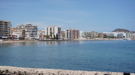
Where is located Playa de Levante
Playa de Levante — local attraction, which is located at Region of Murcia and belongs to the category — -. Average visitor rating for this place — 4.1 (according to 40 ratings, information from open sources and relevant for 2022).
Exact location — Playa de Levante, marked on the map with a red marker.
You can get directions to Playa de Levante on the map from your location.
What else is interesting in Águilas? You can see all the sights if you go to the city page.
Coordinates
Playa de Levante, Spain coordinates in decimal format: latitude — 37.40639257896176, longitude — -1.5769498251435106. When converted to degrees, minutes, seconds Playa de Levante has the following coordinates: 37°24′23.01 north latitude and -1°34′37.02 east longitude.
Nearby cities
The largest cities that are located nearby:
- Cartagena — 57 km
- Murcia — 75 km
- Almería — 101 km
- Albacete — 177 km
- Granada — 179 km
- Jaén — 197 km
- Oran
 (Algeria) — 208 km
 - Valencia — 250 km
- Sidi Bel Abbes (Algeria) — 259 km
- Málaga — 263 km
- Relizane (Algeria) — 267 km
- Nador
 (Morocco) — 277 km
 - Tlemcen (Algeria) — 281 km
- Córdoba — 284 km
- Chlef (Algeria) — 294 km
- Oujda (Morocco) — 303 km
- Marbella — 310 km
- Saida (Algeria) — 325 km
- Getafe — 368 km
Distance to the capital
Distance to the capital (Madrid) is about — 382 km.