
 Maureville
Samoëns
Gréning
Toulouse
Volx
Goudet
Méhoncourt
Saint-Hymer
Pontcarré
Maureville
Samoëns
Gréning
Toulouse
Volx
Goudet
Méhoncourt
Saint-Hymer
Pontcarré
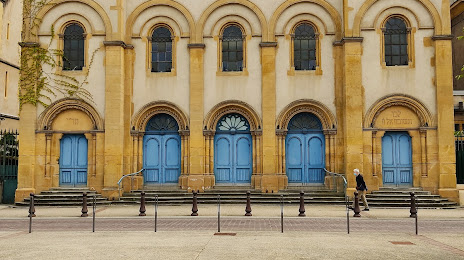
Synagogue (Synagogue de Metz) on the map, Montigny-lès-Metz, France
Photo
Where is located Synagogue (Synagogue de Metz)
Synagogue (Synagogue de Metz) — local attraction, which is located at 39 Rue du Rabbin Élie Bloch, 57000 Metz, France and belongs to the category — synagogue. Average visitor rating for this place — 4.4 (according to 82 ratings, information from open sources and relevant for 2022).
Exact location — Synagogue (Synagogue de Metz), marked on the map with a red marker.
You can get directions to Synagogue (Synagogue de Metz) on the map from your location.
What else is interesting in Montigny-lès-Metz? You can see all the sights if you go to the city page.
Coordinates
Synagogue (Synagogue de Metz), France coordinates in decimal format: latitude — 49.10077134713202, longitude — 6.154729231049704. When converted to degrees, minutes, seconds Synagogue (Synagogue de Metz) has the following coordinates: 49°6′2.78 north latitude and 6°9′17.03 east longitude.
Nearby cities
The largest cities that are located nearby:
- Metz — 3 km
- Nancy — 45 km
- Saarbrücken
 (Germany) — 63 km
 - Trier (Germany) — 80 km
- Strasbourg — 131 km
- Reims — 154 km
- Karlsruhe (Germany) — 164 km
- Ludwigshafen (Germany) — 170 km
- Mannheim (Germany) — 172 km
- Koblenz (Germany) — 172 km
- Mulhouse — 173 km
- Liège
 (Belgium) — 174 km
 - Freiburg (Germany) — 175 km
- Namur (Belgium) — 176 km
- Mainz (Germany) — 179 km
- Wiesbaden (Germany) — 184 km
- Heidelberg (Germany) — 185 km
- Aachen (Germany) — 185 km
- Pforzheim (Germany) — 187 km
Distance to the capital
Distance to the capital (Paris) is about — 279 km.