
 Bel-Ha
San Jose El Alto
El Porvenir
Nueva Palestina
Santa Lucía
Chemax
La Morita
Temoac
Zacualpan
Bel-Ha
San Jose El Alto
El Porvenir
Nueva Palestina
Santa Lucía
Chemax
La Morita
Temoac
Zacualpan
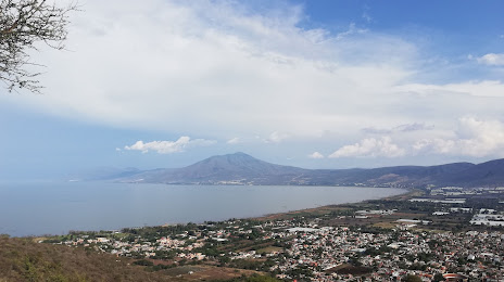
Sierra de San Juan Cosalá on the map, Ajijic, Mexico
Photo
Where is located Sierra de San Juan Cosalá
Sierra de San Juan Cosalá — local attraction, which is located at Sin nombre No. 1744 2545, Fidel Velázquez, 44220 Guadalajara, Jal., Mexico and belongs to the category — national park. Average visitor rating for this place — 4.6 (according to 549 ratings, information from open sources and relevant for 2022).
Exact location — Sierra de San Juan Cosalá, marked on the map with a red marker.
You can get directions to Sierra de San Juan Cosalá on the map from your location.
What else is interesting in Ajijic? You can see all the sights if you go to the city page.
Coordinates
Sierra de San Juan Cosalá, Mexico coordinates in decimal format: latitude — 20.3076940620427, longitude — -103.3055029668782. When converted to degrees, minutes, seconds Sierra de San Juan Cosalá has the following coordinates: 20°18′27.7 north latitude and -103°18′19.81 east longitude.
Nearby cities
The largest cities that are located nearby:
- Tonalá — 36 km
- Tlaquepaque — 38 km
- Guadalajara — 41 km
- Zapopan — 44 km
- Zamora — 107 km
- Colima — 126 km
- Uruapan — 161 km
- Manzanillo — 173 km
- León — 187 km
- Aguascalientes — 202 km
- Irapuato — 202 km
- Puerto Vallarta — 207 km
- Tepic — 214 km
- Salamanca — 216 km
- Morelia — 225 km
- Celaya — 255 km
- Zacatecas — 282 km
- Santiago de Querétaro — 299 km
- San Luis Potosi — 311 km
Distance to the capital
Distance to the capital (Mexico City) is about — 447 km.