
 Maureville
Samoëns
Gréning
Toulouse
Volx
Goudet
Méhoncourt
Saint-Hymer
Pontcarré
Maureville
Samoëns
Gréning
Toulouse
Volx
Goudet
Méhoncourt
Saint-Hymer
Pontcarré
Park Charles De Gaulle on the map, Sartrouville, France
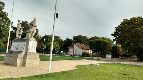
Photo
Where is located Park Charles De Gaulle
Park Charles De Gaulle — local attraction, which is located at 5 All. du 8 Mai 1945, 78800 Houilles, France and belongs to the category — city park. Average visitor rating for this place — 4.5 (according to 0 ratings, information from open sources and relevant for 2022).
Exact location — Park Charles De Gaulle, marked on the map with a red marker.
You can get directions to Park Charles De Gaulle on the map from your location.
What else is interesting in Sartrouville? You can see all the sights if you go to the city page.
Coordinates
Park Charles De Gaulle, France coordinates in decimal format: latitude — 48.92139023218944, longitude — 2.1057438129705353. When converted to degrees, minutes, seconds Park Charles De Gaulle has the following coordinates: 48°55′17 north latitude and 2°6′20.68 east longitude.
Nearby cities
The largest cities that are located nearby:
- Boulogne-Billancourt — 13 km
- Rouen — 94 km
- Amiens — 106 km
- Orléans — 116 km
- Reims — 140 km
- Le Havre — 159 km
- Le Mans — 178 km
- Caen — 185 km
- Lille — 197 km
- Tours — 204 km
- Charleroi
 (Belgium) — 229 km
 - Eastbourne
 (United Kingdom) — 241 km
 - Namur (Belgium) — 255 km
- Angers — 260 km
- Brussels (Belgium) — 261 km
- Dijon — 281 km
- Crawley (United Kingdom) — 290 km
- Metz — 291 km
- Gillingham (United Kingdom) — 292 km
Distance to the capital
Distance to the capital (Paris) is about — 19 km.