
 Belém
Maranguape
Paranaguá
Paranaguá
Monte Alegre
Alvorada de Minas
Bragança
Laguna
Ibiporã
Belém
Maranguape
Paranaguá
Paranaguá
Monte Alegre
Alvorada de Minas
Bragança
Laguna
Ibiporã
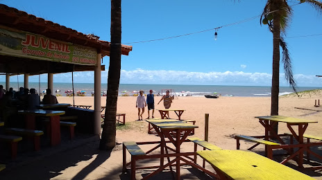
Ipiranga Pontal Beach (Praia de Pontal do Ipiranga) on the map, Linhares, Brazil
Photo
Where is located Ipiranga Pontal Beach (Praia de Pontal do Ipiranga)
Ipiranga Pontal Beach (Praia de Pontal do Ipiranga) — local attraction, which is located at no data and belongs to the category — -. Average visitor rating for this place — 4.5 (according to 938 ratings, information from open sources and relevant for 2022).
Exact location — Ipiranga Pontal Beach (Praia de Pontal do Ipiranga), marked on the map with a red marker.
You can get directions to Ipiranga Pontal Beach (Praia de Pontal do Ipiranga) on the map from your location.
What else is interesting in Linhares? You can see all the sights if you go to the city page.
Coordinates
Ipiranga Pontal Beach (Praia de Pontal do Ipiranga), Brazil coordinates in decimal format: latitude — -19.19889320471017, longitude — -39.7062724475851. When converted to degrees, minutes, seconds Ipiranga Pontal Beach (Praia de Pontal do Ipiranga) has the following coordinates: -19°11′56.02 north latitude and -39°42′22.58 east longitude.
Nearby cities
The largest cities that are located nearby:
- Colatina — 65 km
- Serra — 84 km
- Cariacica — 103 km
- Vila Velha — 108 km
- Guarapari — 148 km
- Cachoeiro de Itapemirim — 194 km
- Valadares Governor — 207 km
- Teófilo Otoni — 228 km
- Coronel Fabriciano — 267 km
- Porto Seguro — 343 km
- Macaé — 374 km
- Sabará — 395 km
- Santa Luzia — 405 km
- Belo Horizonte — 406 km
- Ribeirão das Neves — 420 km
- Ibirité — 421 km
- Contagem — 421 km
- Juiz de Fora — 426 km
- Esmeraldas — 431 km