
 Litoral Del Bajo San Juan
El Cantón de San Pablo
Juan Frío
Santa Barbara
El Juncal
Dibulla
Vereda Campo Alegre
San Pablo
Guaramito
Litoral Del Bajo San Juan
El Cantón de San Pablo
Juan Frío
Santa Barbara
El Juncal
Dibulla
Vereda Campo Alegre
San Pablo
Guaramito
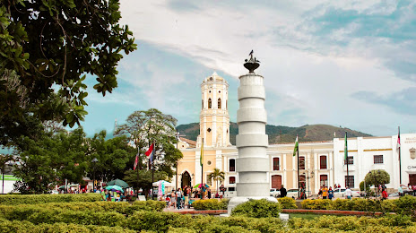
Parque Principal on the map, Ocaña, Colombia
Photo
Where is located Parque Principal
Parque Principal — local attraction, which is located at Ocaña, North Santander, Colombia and belongs to the category — park. Average visitor rating for this place — 4.5 (according to 3295 ratings, information from open sources and relevant for 2022).
Exact location — Parque Principal, marked on the map with a red marker.
You can get directions to Parque Principal on the map from your location.
What else is interesting in Ocaña? You can see all the sights if you go to the city page.
Coordinates
Parque Principal, Colombia coordinates in decimal format: latitude — 8.235380003078483, longitude — -73.3539419757641. When converted to degrees, minutes, seconds Parque Principal has the following coordinates: 8°14′7.37 north latitude and -73°21′14.19 east longitude.
Nearby cities
The largest cities that are located nearby:
- Cúcuta — 101 km
- Bucaramanga — 127 km
- Giron — 132 km
- San Cristobal
 (Venezuela) — 134 km
 - Floridablanca — 135 km
- Barrancabermeja — 143 km
- Magangué — 188 km
- Ejido (Venezuela) — 233 km
- Merida (Venezuela) — 244 km
- Valledupar — 246 km
- Sincelejo — 252 km
- Monteria — 282 km
- Sogamoso — 284 km
- Tunja — 299 km
- Cabimas (Venezuela) — 313 km
- Bello — 322 km
- Maracaibo (Venezuela) — 323 km
- Malambo — 327 km
- Medellín — 328 km
Distance to the capital
Distance to the capital (Bogota) is about — 412 km.