 Warner Robins
Wantagh
Bethel
Misty Hill Farm
United States
Wakonda Beach (R33) Airport
Wilmington
Poland
Miami International Airport
Warner Robins
Wantagh
Bethel
Misty Hill Farm
United States
Wakonda Beach (R33) Airport
Wilmington
Poland
Miami International Airport
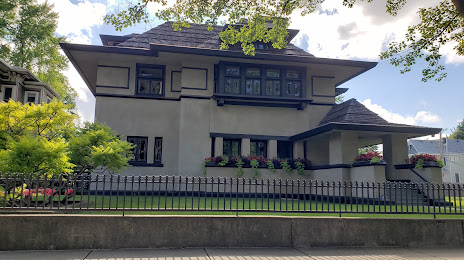
The Hills-DeCaro House - Frank Lloyd Wright on the map, River Forest, United States
Photo
Where is located The Hills-DeCaro House - Frank Lloyd Wright
The Hills-DeCaro House - Frank Lloyd Wright — local attraction, which is located at 313 Forest Ave, Oak Park, IL 60302, United States and belongs to the category — historical landmark. Average visitor rating for this place — 4.7 (according to 7 ratings, information from open sources and relevant for 2022).
Exact location — The Hills-DeCaro House - Frank Lloyd Wright, marked on the map with a red marker.
You can get directions to The Hills-DeCaro House - Frank Lloyd Wright on the map from your location.
What else is interesting in River Forest? You can see all the sights if you go to the city page.
Coordinates
The Hills-DeCaro House - Frank Lloyd Wright, United States coordinates in decimal format: latitude — 41.89235604647238, longitude — -87.80072427510359. When converted to degrees, minutes, seconds The Hills-DeCaro House - Frank Lloyd Wright has the following coordinates: 41°53′32.48 north latitude and -87°48′2.61 east longitude.
Nearby cities
The largest cities that are located nearby:
- Chicago — 15 km
- Naperville — 32 km
- Aurora — 44 km
- Joliet — 47 km
- Rockford — 113 km
- Milwaukee — 126 km
- South Bend — 131 km
- Madison — 183 km
- Peoria — 200 km
- Grand Rapids — 210 km
- Fort Wayne — 241 km
- Indianapolis — 274 km
- Lansing — 280 km
- Green Bay — 290 km
- Ann Arbor — 336 km
- Toledo — 353 km
- Flint — 356 km
- Detroit — 393 km
- Windsor
 (Canada) — 393 km
Distance to the capital
Distance to the capital (Washington) is about — 969 km.