
 Puerto de la Duquesa
La Serna de Iguña
Pumalverde
Puentenansa
La Iglesia
Casar de Periedo
Fuengirola
Renedo de Piélagos
Villabanez
Puerto de la Duquesa
La Serna de Iguña
Pumalverde
Puentenansa
La Iglesia
Casar de Periedo
Fuengirola
Renedo de Piélagos
Villabanez
Laguna El Raso on the map, Mejorada del Campo, Spain
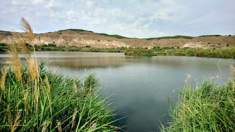
Photo
Where is located Laguna El Raso
Laguna El Raso — local attraction, which is located at C. P.º de la Laguna, 1, 28891 Velilla de San Antonio, Madrid, Spain and belongs to the category — hiking area. Average visitor rating for this place — 4.3 (according to 114 ratings, information from open sources and relevant for 2022).
Exact location — Laguna El Raso, marked on the map with a red marker.
You can get directions to Laguna El Raso on the map from your location.
What else is interesting in Mejorada del Campo? You can see all the sights if you go to the city page.
Coordinates
Laguna El Raso, Spain coordinates in decimal format: latitude — 40.36428609299612, longitude — -3.4971347750562316. When converted to degrees, minutes, seconds Laguna El Raso has the following coordinates: 40°21′51.43 north latitude and -3°29′49.69 east longitude.
Nearby cities
The largest cities that are located nearby:
- Torrejón de Ardoz — 7 km
- Alcala de Henares — 14 km
- Alcobendas — 20 km
- Getafe — 23 km
- Leganés — 25 km
- Fuenlabrada — 29 km
- Alcorcón — 29 km
- Móstoles — 33 km
- Valladolid — 172 km
- Salamanca — 192 km
- Albacete — 209 km
- Burgos — 216 km
- Logroño — 244 km
- Zaragoza — 255 km
- Vitoria-Gasteiz — 280 km
- Valencia — 285 km
- Jaén — 291 km
- León — 297 km
- Córdoba — 299 km
Distance to the capital
Distance to the capital (Madrid) is about — 18 km.