
 Calahorra
Albuixec
Olivar
Almonte
Carrocera
Olivenza
Vilalba
Alàs
Las Torres de Cotillas
Amorebieta-Etxano
Campo de Criptana
Arca
Zafra
Sierra de Yeguas
Almedíjar
Pradillo
Crevillent
Palomar de Arroyos
Peque
Calahorra
Albuixec
Olivar
Almonte
Carrocera
Olivenza
Vilalba
Alàs
Las Torres de Cotillas
Amorebieta-Etxano
Campo de Criptana
Arca
Zafra
Sierra de Yeguas
Almedíjar
Pradillo
Crevillent
Palomar de Arroyos
Peque
Mejorada del Campo on the map, Spain
Where is located Mejorada del Campo
Exact location — Mejorada del Campo, Madrid, Comunidad de Madrid, Spain, marked on the map with a red marker.
Coordinates
Mejorada del Campo, Spain coordinates in decimal format: latitude — 40.396654, longitude — -3.4877129. When converted to degrees, minutes, seconds Mejorada del Campo has the following coordinates: 40°23′47.95 north latitude and -3°29′15.77 east longitude.
Population
Mejorada del Campo, Madrid, Comunidad de Madrid, Spain, according to our data the population is — 19,019 residents, which is about 0% of the total population of the country (Spain).
Comparison of the population on the graph:
Exact time
Time zone for this location Mejorada del Campo — UTC +2 Europe/Madrid. Exact time — sunday, 4 april 2024 year, 18 h. 27 minutes.
Sunrise and sunset
Mejorada del Campo, sunrise and sunset data for a date — sunday 28.04.2024.
| Sunrise | Sunset | Day (duration) |
|---|---|---|
| 07:19 -1 minute | 21:03 +1 minute | 13 h. 42 minutes. +2 minutes |
You can control the scale of the map using the auxiliary tools to find out exactly where it is located Mejorada del Campo. When you change the scale of the map, the width of the ruler also changes (in kilometers and miles).
Nearby cities
The largest cities that are located nearby:
- Torrejón de Ardoz — 7 km
- Alcala de Henares — 14 km
- Alcobendas — 20 km
- Getafe — 23 km
- Leganés — 25 km
- Fuenlabrada — 29 km
- Alcorcón — 29 km
- Móstoles — 33 km
- Valladolid — 172 km
- Salamanca — 192 km
- Albacete — 209 km
- Burgos — 216 km
- Logroño — 244 km
- Zaragoza — 255 km
- Vitoria-Gasteiz — 280 km
- Valencia — 285 km
- Jaén — 291 km
- León — 297 km
- Córdoba — 299 km
Distance to neighboring capitals:
- Andorra la Vella
 (Andorra) — 479 km
 - Lisbon
 (Portugal) — 519 km
 - Rabat
 (Morocco) — 774 km
 - Paris
 (France) — 1048 km
 - Paris (France) — 1048 km
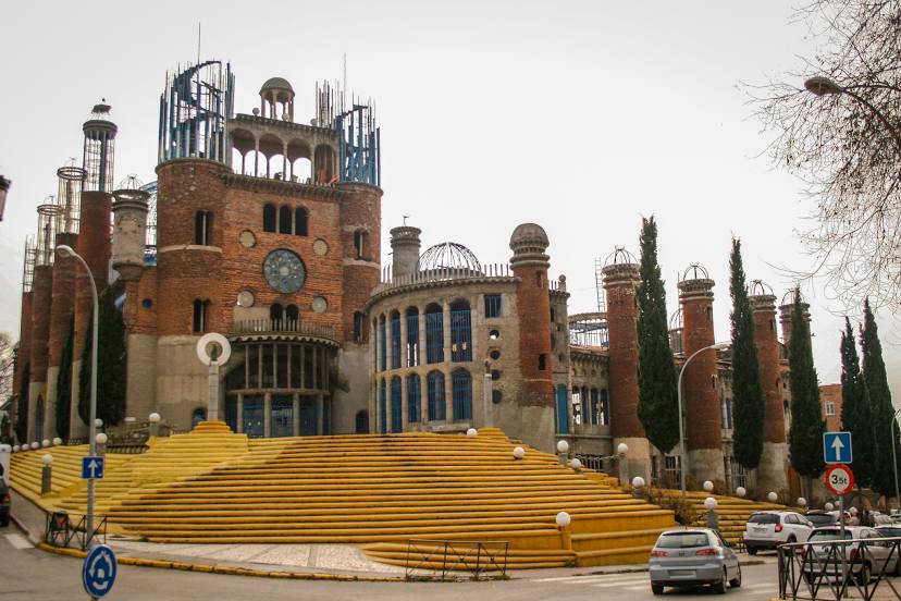
Attractions
Distance to the capital
Distance to the capital (Madrid) is about — 18 km.