
 Puerto de la Duquesa
La Serna de Iguña
Pumalverde
Puentenansa
La Iglesia
Casar de Periedo
Fuengirola
Renedo de Piélagos
Villabanez
Puerto de la Duquesa
La Serna de Iguña
Pumalverde
Puentenansa
La Iglesia
Casar de Periedo
Fuengirola
Renedo de Piélagos
Villabanez
Las Sierras Subbéticas Natural Park on the map, Cabra, Spain
Photo
Where is located Las Sierras Subbéticas Natural Park
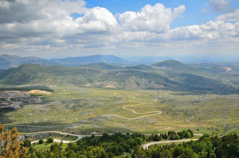
Las Sierras Subbéticas Natural Park — local attraction, which is located at Cabra, Córdoba, Spain and belongs to the category — park. Average visitor rating for this place — 4.7 (according to 2306 ratings, information from open sources and relevant for 2022).
Exact location — las Sierras Subbéticas Natural Park, marked on the map with a red marker.
You can get directions to Las Sierras Subbéticas Natural Park on the map from your location.
What else is interesting in Cabra? You can see all the sights if you go to the city page.
Coordinates
las Sierras Subbéticas Natural Park, Spain coordinates in decimal format: latitude — 37.4527877527139, longitude — -4.3360278751421735. When converted to degrees, minutes, seconds las Sierras Subbéticas Natural Park has the following coordinates: 37°27′10.04 north latitude and -4°20′9.7 east longitude.
Nearby cities
The largest cities that are located nearby:
- Córdoba — 54 km
- Jaén — 67 km
- Granada — 81 km
- Málaga — 83 km
- Marbella — 113 km
- Dos Hermanas — 132 km
- Jerez — 173 km
- Algeciras — 173 km
- Almería — 189 km
- Cádiz — 195 km
- Huelva — 221 km
- Tetouan
 (Morocco) — 227 km
 - Tangier (Morocco) — 227 km
- Badajoz — 267 km
- Albacete — 279 km
- Nador (Morocco) — 289 km
- Murcia — 294 km
- Cartagena — 302 km
- Fuenlabrada — 316 km
Distance to the capital
Distance to the capital (Madrid) is about — 334 km.