
 Puerto de la Duquesa
La Serna de Iguña
Pumalverde
Puentenansa
La Iglesia
Casar de Periedo
Fuengirola
Renedo de Piélagos
Villabanez
Puerto de la Duquesa
La Serna de Iguña
Pumalverde
Puentenansa
La Iglesia
Casar de Periedo
Fuengirola
Renedo de Piélagos
Villabanez
Museo Comarcal de Daimiel on the map, Daimiel, Spain
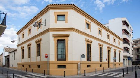
Photo
Where is located Museo Comarcal de Daimiel
Museo Comarcal de Daimiel — local attraction, which is located at C. Luis Ruiz Valdepeñas, 8, 13250 Daimiel, Cdad. Real, Spain and belongs to the category — archaeological museum. Average visitor rating for this place — 4.3 (according to 380 ratings, information from open sources and relevant for 2022).
Exact location — Museo Comarcal de Daimiel, marked on the map with a red marker.
You can get directions to Museo Comarcal de Daimiel on the map from your location.
What else is interesting in Daimiel? You can see all the sights if you go to the city page.
Coordinates
Museo Comarcal de Daimiel, Spain coordinates in decimal format: latitude — 39.06929149590497, longitude — -3.6112403750951176. When converted to degrees, minutes, seconds Museo Comarcal de Daimiel has the following coordinates: 39°4′9.45 north latitude and -3°36′40.47 east longitude.
Nearby cities
The largest cities that are located nearby:
- Fuenlabrada — 136 km
- Getafe — 137 km
- Leganés — 140 km
- Móstoles — 140 km
- Alcorcón — 142 km
- Jaén — 143 km
- Albacete — 151 km
- Torrejón de Ardoz — 154 km
- Alcala de Henares — 158 km
- Alcobendas — 162 km
- Córdoba — 166 km
- Granada — 209 km
- Murcia — 247 km
- Almería — 267 km
- Málaga — 269 km
- Salamanca — 271 km
- Cartagena — 279 km
- Valencia — 280 km
- Dos Hermanas — 283 km
Distance to the capital
Distance to the capital (Madrid) is about — 150 km.