
 Józefów nad Wisłą
Gorzyce Wielkie
Rogówek
Sromowce Niżne
Wyszków County
Kruszewo
Jantar
Sady Górne
Nagoszewo
Józefów nad Wisłą
Gorzyce Wielkie
Rogówek
Sromowce Niżne
Wyszków County
Kruszewo
Jantar
Sady Górne
Nagoszewo
Museum of Folk Culture in Kolbuszowa (Muzeum Kultury Ludowej w Kolbuszowej) on the map, Kolbuszowa, Poland
Photo
Where is located Museum of Folk Culture in Kolbuszowa (Muzeum Kultury Ludowej w Kolbuszowej)
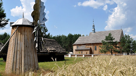
Museum of Folk Culture in Kolbuszowa (Muzeum Kultury Ludowej w Kolbuszowej) — local attraction, which is located at Wolska 36, 36-100 Kolbuszowa, Poland and belongs to the category — ethnographic museum. Average visitor rating for this place — 4.7 (according to 1165 ratings, information from open sources and relevant for 2022).
Exact location — Museum of Folk Culture in Kolbuszowa (Muzeum Kultury Ludowej w Kolbuszowej), marked on the map with a red marker.
You can get directions to Museum of Folk Culture in Kolbuszowa (Muzeum Kultury Ludowej w Kolbuszowej) on the map from your location.
What else is interesting in Kolbuszowa? You can see all the sights if you go to the city page.
Coordinates
Museum of Folk Culture in Kolbuszowa (Muzeum Kultury Ludowej w Kolbuszowej), Poland coordinates in decimal format: latitude — 50.224687891096806, longitude — 21.75604102527264. When converted to degrees, minutes, seconds Museum of Folk Culture in Kolbuszowa (Muzeum Kultury Ludowej w Kolbuszowej) has the following coordinates: 50°13′28.88 north latitude and 21°45′21.75 east longitude.
Nearby cities
The largest cities that are located nearby:
- Rzeszow — 27 km
- Tarnow — 62 km
- Kielce — 106 km
- Lublin — 124 km
- Kraków — 131 km
- Radom — 135 km
- Košice
 (Slovakia) — 173 km
 - Dabrowa Gornicza — 182 km
- Uzhhorod
 (Ukraine) — 183 km
 - Sosnowiec — 189 km
- Katowice — 195 km
- Częstochowa — 196 km
- Chorzow — 199 km
- Bielsko-Biala — 199 km
- Bytom — 202 km
- Ruda Slaska — 206 km
- Zabrze — 211 km
- Gliwice — 219 km
- Rybnik — 230 km
Distance to the capital
Distance to the capital (Warsaw) is about — 229 km.