
 Puerto de la Duquesa
La Serna de Iguña
Pumalverde
Puentenansa
La Iglesia
Casar de Periedo
Fuengirola
Renedo de Piélagos
Villabanez
Puerto de la Duquesa
La Serna de Iguña
Pumalverde
Puentenansa
La Iglesia
Casar de Periedo
Fuengirola
Renedo de Piélagos
Villabanez
Pinedo Beach on the map, Alfafar, Spain
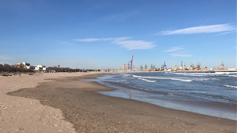
Photo
Where is located Pinedo Beach
Pinedo Beach — local attraction, which is located at no data and belongs to the category — -. Average visitor rating for this place — 4.3 (according to 1981 rating, information from open sources and relevant for 2022).
Exact location — Pinedo Beach, marked on the map with a red marker.
You can get directions to Pinedo Beach on the map from your location.
What else is interesting in Alfafar? You can see all the sights if you go to the city page.
Coordinates
Pinedo Beach, Spain coordinates in decimal format: latitude — 39.4210885333925, longitude — -0.33304342508468304. When converted to degrees, minutes, seconds Pinedo Beach has the following coordinates: 39°25′15.92 north latitude and -0°19′58.96 east longitude.
Nearby cities
The largest cities that are located nearby:
- Valencia — 6 km
- Albacete — 134 km
- Murcia — 170 km
- Cartagena — 205 km
- Tarragona — 233 km
- Zaragoza — 250 km
- Lleida — 257 km
- Palma — 261 km
- Alcala de Henares — 276 km
- Torrejón de Ardoz — 283 km
- Getafe — 298 km
- Alcobendas — 299 km
- L'Hospitalet de Llobregat — 300 km
- Leganés — 301 km
- Fuenlabrada — 303 km
- Alcorcón — 307 km
- Móstoles — 309 km
- Terrassa — 310 km
- Santa Coloma de Gramenet — 312 km
Distance to the capital
Distance to the capital (Madrid) is about — 308 km.