
 Maureville
Samoëns
Gréning
Toulouse
Volx
Goudet
Méhoncourt
Saint-Hymer
Pontcarré
Maureville
Samoëns
Gréning
Toulouse
Volx
Goudet
Méhoncourt
Saint-Hymer
Pontcarré
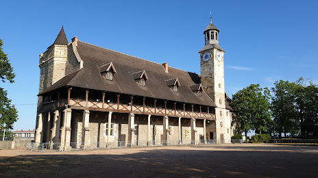
Castle of the dukes of Bourbon in Montluçon on the map, Montluçon, France
Photo
Where is located Castle of the dukes of Bourbon in Montluçon
Castle of the dukes of Bourbon in Montluçon — local attraction, which is located at Rue du Château, 03100 Montluçon, France and belongs to the category — castle. Average visitor rating for this place — 4.1 (according to 424 ratings, information from open sources and relevant for 2022).
Exact location — Castle of the dukes of Bourbon in Montluçon, marked on the map with a red marker.
You can get directions to Castle of the dukes of Bourbon in Montluçon on the map from your location.
What else is interesting in Montluçon? You can see all the sights if you go to the city page.
Coordinates
Castle of the dukes of Bourbon in Montluçon, France coordinates in decimal format: latitude — 46.34267638340255, longitude — 2.6073135577229105. When converted to degrees, minutes, seconds Castle of the dukes of Bourbon in Montluçon has the following coordinates: 46°20′33.63 north latitude and 2°36′26.33 east longitude.
Nearby cities
The largest cities that are located nearby:
- Clermont-Ferrand — 73 km
- Limoges — 118 km
- Saint-Étienne — 171 km
- Orléans — 180 km
- Lyon — 184 km
- Tours — 185 km
- Villeurbanne — 187 km
- Dijon — 213 km
- Le Mans — 256 km
- Angers — 268 km
- Geneva
 (Switzerland) — 271 km
 - Grenoble — 275 km
- Besançon — 275 km
- Boulogne-Billancourt — 277 km
- Bordeaux — 300 km
- Lausanne (Switzerland) — 307 km
- Nimes — 310 km
- Toulouse — 316 km
- Montpellier — 319 km
Distance to the capital
Distance to the capital (Paris) is about — 280 km.