
 Maureville
Samoëns
Gréning
Toulouse
Volx
Goudet
Méhoncourt
Saint-Hymer
Pontcarré
Maureville
Samoëns
Gréning
Toulouse
Volx
Goudet
Méhoncourt
Saint-Hymer
Pontcarré
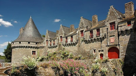
Castle of Rohan Dukes on the map, Pontivy, France
Photo
Where is located Castle of Rohan Dukes
Castle of Rohan Dukes — local attraction, which is located at 63 Rue du Général de Gaulle, 56300 Pontivy, France and belongs to the category — castle. Average visitor rating for this place — 4.0 (according to 441 rating, information from open sources and relevant for 2022).
Exact location — Castle of Rohan Dukes, marked on the map with a red marker.
You can get directions to Castle of Rohan Dukes on the map from your location.
What else is interesting in Pontivy? You can see all the sights if you go to the city page.
Coordinates
Castle of Rohan Dukes, France coordinates in decimal format: latitude — 48.0701326177038, longitude — -2.963492974803916. When converted to degrees, minutes, seconds Castle of Rohan Dukes has the following coordinates: 48°4′12.48 north latitude and -2°57′48.57 east longitude.
Nearby cities
The largest cities that are located nearby:
- Rennes — 95 km
- Brest — 117 km
- Nantes — 142 km
- Angers — 191 km
- Caen — 225 km
- Le Mans — 234 km
- Le Havre — 271 km
- Tours — 283 km
- Exeter
 (United Kingdom) — 296 km
 - Bournemouth (United Kingdom) — 303 km
- Rouen — 330 km
- Portsmouth (United Kingdom) — 332 km
- Southampton (United Kingdom) — 333 km
- Orléans — 362 km
- Bristol (Great Britain) — 376 km
- Eastbourne (United Kingdom) — 376 km
- Crawley (United Kingdom) — 388 km
- Boulogne-Billancourt — 388 km
- Swindon (United Kingdom) — 394 km
Distance to the capital
Distance to the capital (Paris) is about — 402 km.