
 Maureville
Samoëns
Gréning
Toulouse
Volx
Goudet
Méhoncourt
Saint-Hymer
Pontcarré
Maureville
Samoëns
Gréning
Toulouse
Volx
Goudet
Méhoncourt
Saint-Hymer
Pontcarré
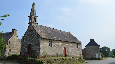
Chapelle Sainte-Tréphine on the map, Pontivy, France
Photo
Where is located Chapelle Sainte-Tréphine
Chapelle Sainte-Tréphine — local attraction, which is located at 2 Rue du Hent Bihan, 56300 Pontivy, France and belongs to the category — chapel. Average visitor rating for this place — 4.7 (according to 7 ratings, information from open sources and relevant for 2022).
Exact location — Chapelle Sainte-Tréphine, marked on the map with a red marker.
You can get directions to Chapelle Sainte-Tréphine on the map from your location.
What else is interesting in Pontivy? You can see all the sights if you go to the city page.
Coordinates
Chapelle Sainte-Tréphine, France coordinates in decimal format: latitude — 48.06437951409692, longitude — -2.986970674804111. When converted to degrees, minutes, seconds Chapelle Sainte-Tréphine has the following coordinates: 48°3′51.77 north latitude and -2°59′13.09 east longitude.
Nearby cities
The largest cities that are located nearby:
- Rennes — 95 km
- Brest — 117 km
- Nantes — 142 km
- Angers — 191 km
- Caen — 225 km
- Le Mans — 234 km
- Le Havre — 271 km
- Tours — 283 km
- Exeter
 (United Kingdom) — 296 km
 - Bournemouth (United Kingdom) — 303 km
- Rouen — 330 km
- Portsmouth (United Kingdom) — 332 km
- Southampton (United Kingdom) — 333 km
- Orléans — 362 km
- Bristol (Great Britain) — 376 km
- Eastbourne (United Kingdom) — 376 km
- Crawley (United Kingdom) — 388 km
- Boulogne-Billancourt — 388 km
- Swindon (United Kingdom) — 394 km
Distance to the capital
Distance to the capital (Paris) is about — 403 km.