
 Maureville
Samoëns
Gréning
Toulouse
Volx
Goudet
Méhoncourt
Saint-Hymer
Pontcarré
Maureville
Samoëns
Gréning
Toulouse
Volx
Goudet
Méhoncourt
Saint-Hymer
Pontcarré
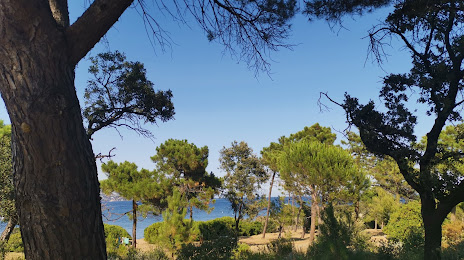
Pointe des Sardinaux on the map, Sainte-Maxime, France
Photo
Where is located Pointe des Sardinaux
Pointe des Sardinaux — local attraction, which is located at 1-3 Av. Général Touzet du Vigier, 83120 Sainte-Maxime, France and belongs to the category — observation deck. Average visitor rating for this place — 4.5 (according to 549 ratings, information from open sources and relevant for 2022).
Exact location — Pointe des Sardinaux, marked on the map with a red marker.
You can get directions to Pointe des Sardinaux on the map from your location.
What else is interesting in Sainte-Maxime? You can see all the sights if you go to the city page.
Coordinates
Pointe des Sardinaux, France coordinates in decimal format: latitude — 43.31365608481629, longitude — 6.671021890790299. When converted to degrees, minutes, seconds Pointe des Sardinaux has the following coordinates: 43°18′49.16 north latitude and 6°40′15.68 east longitude.
Nearby cities
The largest cities that are located nearby:
- Toulon — 61 km
- Nice — 67 km
- Aix-en-Provence — 99 km
- Marseille — 102 km
- Nimes — 191 km
- Turin
 (Italy) — 211 km
 - Genoa (Italy) — 219 km
- Grenoble — 220 km
- Montpellier — 224 km
- Novara (Italy) — 282 km
- Saint-Étienne — 293 km
- Livorno (Italy) — 295 km
- Villeurbanne — 304 km
- Lyon — 305 km
- Milan (Italy) — 309 km
- Perpignan — 312 km
- Geneva
 (Switzerland) — 322 km
 - Monza (Italy) — 324 km
- Sassari (Italy) — 328 km
Distance to the capital
Distance to the capital (Paris) is about — 701 km.