
 Maureville
Samoëns
Gréning
Toulouse
Volx
Goudet
Méhoncourt
Saint-Hymer
Pontcarré
Maureville
Samoëns
Gréning
Toulouse
Volx
Goudet
Méhoncourt
Saint-Hymer
Pontcarré
Musée De La Liberation Du Muy on the map, Sainte-Maxime, France
Photo
Where is located Musée De La Liberation Du Muy
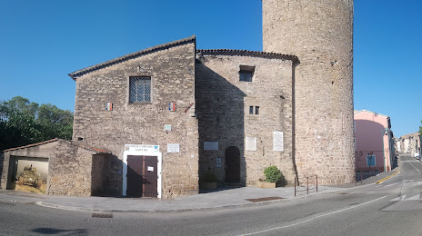
Musée De La Liberation Du Muy — local attraction, which is located at rn7 tour Charles Quint, 83490, Le Muy, France and belongs to the category — museum. Average visitor rating for this place — 4.6 (according to 67 ratings, information from open sources and relevant for 2022).
Exact location — Musée De La Liberation Du Muy, marked on the map with a red marker.
You can get directions to Musée De La Liberation Du Muy on the map from your location.
What else is interesting in Sainte-Maxime? You can see all the sights if you go to the city page.
Coordinates
Musée De La Liberation Du Muy, France coordinates in decimal format: latitude — 43.47181794189423, longitude — 6.569746625041303. When converted to degrees, minutes, seconds Musée De La Liberation Du Muy has the following coordinates: 43°28′18.54 north latitude and 6°34′11.09 east longitude.
Nearby cities
The largest cities that are located nearby:
- Toulon — 61 km
- Nice — 67 km
- Aix-en-Provence — 99 km
- Marseille — 102 km
- Nimes — 191 km
- Turin
 (Italy) — 211 km
 - Genoa (Italy) — 219 km
- Grenoble — 220 km
- Montpellier — 224 km
- Novara (Italy) — 282 km
- Saint-Étienne — 293 km
- Livorno (Italy) — 295 km
- Villeurbanne — 304 km
- Lyon — 305 km
- Milan (Italy) — 309 km
- Perpignan — 312 km
- Geneva
 (Switzerland) — 322 km
 - Monza (Italy) — 324 km
- Sassari (Italy) — 328 km
Distance to the capital
Distance to the capital (Paris) is about — 681 km.