
 Maureville
Samoëns
Gréning
Toulouse
Volx
Goudet
Méhoncourt
Saint-Hymer
Pontcarré
Maureville
Samoëns
Gréning
Toulouse
Volx
Goudet
Méhoncourt
Saint-Hymer
Pontcarré
Alzou on the map, Villefranche-de-Rouergue, France
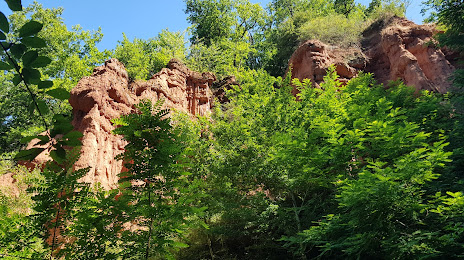
Photo
Where is located Alzou
Alzou — local attraction, which is located at 44 km and belongs to the category — -. Average visitor rating for this place — 4.4 (according to 38 ratings, information from open sources and relevant for 2022).
Exact location — Alzou, marked on the map with a red marker.
You can get directions to Alzou on the map from your location.
What else is interesting in Villefranche-de-Rouergue? You can see all the sights if you go to the city page.
Coordinates
Alzou, France coordinates in decimal format: latitude — 44.37379633361488, longitude — 2.1727271690705297. When converted to degrees, minutes, seconds Alzou has the following coordinates: 44°22′25.67 north latitude and 2°10′21.82 east longitude.
Nearby cities
The largest cities that are located nearby:
- Toulouse — 95 km
- Montpellier — 169 km
- Limoges — 175 km
- Clermont-Ferrand — 177 km
- Nimes — 194 km
- Perpignan — 196 km
- Bordeaux — 212 km
- Saint-Étienne — 219 km
- Lyon — 267 km
- Villeurbanne — 271 km
- Aix-en-Provence — 288 km
- Marseille — 293 km
- Grenoble — 302 km
- Terrassa
 (Spain) — 308 km
 - Sabadell (Spain) — 310 km
- Mataró (Spain) — 313 km
- Badalona (Spain) — 321 km
- Santa Coloma de Gramenet (Spain) — 322 km
- Lleida (Spain) — 324 km
Distance to the capital
Distance to the capital (Paris) is about — 499 km.