
 Maureville
Samoëns
Gréning
Toulouse
Volx
Goudet
Méhoncourt
Saint-Hymer
Pontcarré
Maureville
Samoëns
Gréning
Toulouse
Volx
Goudet
Méhoncourt
Saint-Hymer
Pontcarré
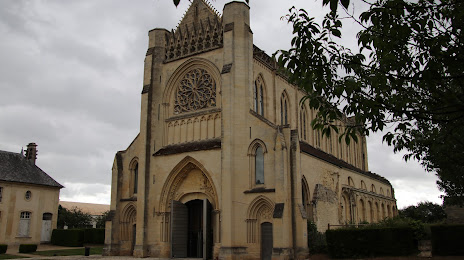
Abbey d’Ardenne - Canadian War Memorial on the map, Hérouville-Saint-Clair, France
Photo
Where is located Abbey d’Ardenne - Canadian War Memorial
Abbey d’Ardenne - Canadian War Memorial — local attraction, which is located at 14280 Saint-Germain-la-Blanche-Herbe, France and belongs to the category — historical landmark. Average visitor rating for this place — 4.7 (according to 60 ratings, information from open sources and relevant for 2022).
Exact location — Abbey d’Ardenne - Canadian War Memorial, marked on the map with a red marker.
You can get directions to Abbey d’Ardenne - Canadian War Memorial on the map from your location.
What else is interesting in Hérouville-Saint-Clair? You can see all the sights if you go to the city page.
Coordinates
Abbey d’Ardenne - Canadian War Memorial, France coordinates in decimal format: latitude — 49.1964857300997, longitude — -0.41354967476419247. When converted to degrees, minutes, seconds Abbey d’Ardenne - Canadian War Memorial has the following coordinates: 49°11′47.35 north latitude and -0°24′48.78 east longitude.
Nearby cities
The largest cities that are located nearby:
- Caen — 4 km
- Le Havre — 45 km
- Rouen — 106 km
- Le Mans — 138 km
- Rennes — 156 km
- Eastbourne
 (United Kingdom) — 178 km
 - Portsmouth (United Kingdom) — 186 km
- Angers — 192 km
- Boulogne-Billancourt — 192 km
- Bournemouth (United Kingdom) — 200 km
- Amiens — 202 km
- Southampton (United Kingdom) — 203 km
- Crawley (United Kingdom) — 211 km
- Tours — 214 km
- Orléans — 220 km
- Nantes — 238 km
- Sutton (United Kingdom) — 239 km
- Gillingham (United Kingdom) — 249 km
- Reading (United Kingdom) — 253 km
Distance to the capital
Distance to the capital (Paris) is about — 205 km.