
 Maureville
Samoëns
Gréning
Toulouse
Volx
Goudet
Méhoncourt
Saint-Hymer
Pontcarré
Maureville
Samoëns
Gréning
Toulouse
Volx
Goudet
Méhoncourt
Saint-Hymer
Pontcarré
Anse de Boumandariel on the map, Châteauneuf-les-Martigues, France
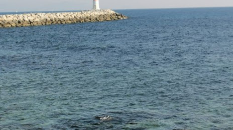
Photo
Where is located Anse de Boumandariel
Anse de Boumandariel — local attraction, which is located at no data and belongs to the category — -. Average visitor rating for this place — 4.0 (according to 7 ratings, information from open sources and relevant for 2022).
Exact location — Anse de Boumandariel, marked on the map with a red marker.
You can get directions to Anse de Boumandariel on the map from your location.
What else is interesting in Châteauneuf-les-Martigues? You can see all the sights if you go to the city page.
Coordinates
Anse de Boumandariel, France coordinates in decimal format: latitude — 43.331589167710064, longitude — 5.090801890827527. When converted to degrees, minutes, seconds Anse de Boumandariel has the following coordinates: 43°19′53.72 north latitude and 5°5′26.89 east longitude.
Nearby cities
The largest cities that are located nearby:
- Marseille — 19 km
- Aix-en-Provence — 28 km
- Toulon — 68 km
- Nimes — 81 km
- Montpellier — 106 km
- Nice — 171 km
- Perpignan — 200 km
- Grenoble — 204 km
- Saint-Étienne — 235 km
- Lyon — 264 km
- Villeurbanne — 265 km
- Turin
 (Italy) — 271 km
 - Toulouse — 299 km
- Mataró
 (Spain) — 304 km
 - Clermont-Ferrand — 309 km
- Genoa (Italy) — 319 km
- Geneva
 (Switzerland) — 320 km
 - Badalona (Spain) — 323 km
- Sabadell (Spain) — 324 km
Distance to the capital
Distance to the capital (Paris) is about — 650 km.