
 Maureville
Samoëns
Gréning
Toulouse
Volx
Goudet
Méhoncourt
Saint-Hymer
Pontcarré
Maureville
Samoëns
Gréning
Toulouse
Volx
Goudet
Méhoncourt
Saint-Hymer
Pontcarré
Puig de Sallafort on the map, Argelès-sur-Mer, France
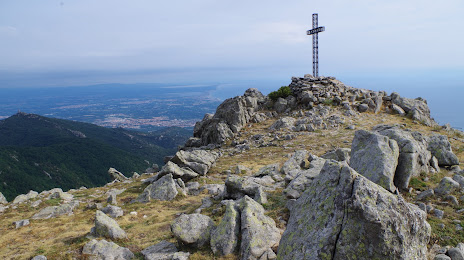
Photo
Where is located Puig de Sallafort
Puig de Sallafort — local attraction, which is located at 981 m and belongs to the category — -. Average visitor rating for this place — 4.1 (according to 11 ratings, information from open sources and relevant for 2022).
Exact location — Puig de Sallafort, marked on the map with a red marker.
You can get directions to Puig de Sallafort on the map from your location.
What else is interesting in Argelès-sur-Mer? You can see all the sights if you go to the city page.
Coordinates
Puig de Sallafort, France coordinates in decimal format: latitude — 42.476755247670916, longitude — 3.0396178890666885. When converted to degrees, minutes, seconds Puig de Sallafort has the following coordinates: 42°28′36.32 north latitude and 3°2′22.62 east longitude.
Nearby cities
The largest cities that are located nearby:
- Perpignan — 19 km
- Mataró
 (Spain) — 121 km
 - Sabadell (Spain) — 134 km
- Montpellier — 136 km
- Terrassa (Spain) — 137 km
- Badalona (Spain) — 138 km
- Santa Coloma de Gramenet (Spain) — 139 km
- L'Hospitalet de Llobregat (Spain) — 151 km
- Toulouse — 172 km
- Nimes — 178 km
- Marseille — 206 km
- Tarragona (Spain) — 216 km
- Aix-en-Provence — 223 km
- Lleida (Spain) — 224 km
- Toulon — 243 km
- Palma (Spain) — 331 km
- Saint-Étienne — 337 km
- Zaragoza (Spain) — 338 km
- Clermont-Ferrand — 357 km
Distance to the capital
Distance to the capital (Paris) is about — 712 km.