
 Maureville
Samoëns
Gréning
Toulouse
Volx
Goudet
Méhoncourt
Saint-Hymer
Pontcarré
Maureville
Samoëns
Gréning
Toulouse
Volx
Goudet
Méhoncourt
Saint-Hymer
Pontcarré
National forest of Marly on the map, Saint-Cyr-l'École, France
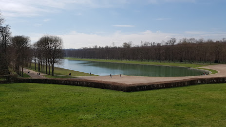
Photo
Where is located National forest of Marly
National forest of Marly — local attraction, which is located at France and belongs to the category — national forest. Average visitor rating for this place — 4.3 (according to 2023 ratings, information from open sources and relevant for 2022).
Exact location — National forest of Marly, marked on the map with a red marker.
You can get directions to National forest of Marly on the map from your location.
What else is interesting in Saint-Cyr-l'École? You can see all the sights if you go to the city page.
Coordinates
National forest of Marly, France coordinates in decimal format: latitude — 48.83198915206881, longitude — 2.082454630095035. When converted to degrees, minutes, seconds National forest of Marly has the following coordinates: 48°49′55.16 north latitude and 2°4′56.84 east longitude.
Nearby cities
The largest cities that are located nearby:
- Boulogne-Billancourt — 13 km
- Rouen — 99 km
- Orléans — 101 km
- Amiens — 121 km
- Reims — 150 km
- Le Havre — 160 km
- Le Mans — 164 km
- Caen — 181 km
- Tours — 187 km
- Lille — 213 km
- Charleroi
 (Belgium) — 244 km
 - Angers — 245 km
- Eastbourne
 (United Kingdom) — 250 km
 - Namur (Belgium) — 270 km
- Brussels (Belgium) — 277 km
- Dijon — 277 km
- Rennes — 287 km
- Crawley (United Kingdom) — 299 km
- Metz — 299 km
Distance to the capital
Distance to the capital (Paris) is about — 20 km.