
 Bel-Ha
San Jose El Alto
El Porvenir
Nueva Palestina
Santa Lucía
Chemax
La Morita
Temoac
Zacualpan
Bel-Ha
San Jose El Alto
El Porvenir
Nueva Palestina
Santa Lucía
Chemax
La Morita
Temoac
Zacualpan
Parque Natural El Encuentro on the map, San Cristóbal de las Casas, Mexico
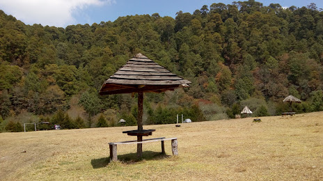
Photo
Where is located Parque Natural El Encuentro
Parque Natural El Encuentro — local attraction, which is located at Periférico Oriente Sur, San Nicolas, 29237 San Cristóbal de las Casas, Chis., Mexico and belongs to the category — park. Average visitor rating for this place — 4.5 (according to 94 ratings, information from open sources and relevant for 2022).
Exact location — Parque Natural El Encuentro, marked on the map with a red marker.
You can get directions to Parque Natural El Encuentro on the map from your location.
What else is interesting in San Cristóbal de las Casas? You can see all the sights if you go to the city page.
Coordinates
Parque Natural El Encuentro, Mexico coordinates in decimal format: latitude — 16.733676553200095, longitude — -92.61504947558329. When converted to degrees, minutes, seconds Parque Natural El Encuentro has the following coordinates: 16°44′1.24 north latitude and -92°36′54.18 east longitude.
Nearby cities
The largest cities that are located nearby:
- Tuxtla Gutiérrez — 49 km
- Villahermosa — 142 km
- Tapachula — 206 km
- Ciudad del Carmen — 229 km
- Quetzaltenango
 (Guatemala) — 242 km
 - Minatitlán — 244 km
- Coatzacoalcos — 246 km
- San Juan Sacatepéquez (Guatemala) — 309 km
- Guatemala City (Guatemala) — 325 km
- Villa Nueva (Guatemala) — 328 km
- Escuintla (Guatemala) — 334 km
- Villa Canales (Guatemala) — 338 km
- Campeche — 406 km
- Oaxaca — 433 km
- Santa Ana
 (El Salvador) — 449 km
 - Apopa (El Salvador) — 493 km
- Santa Tecla (El Salvador) — 494 km
- Chetumal — 495 km
- Mejicanos (El Salvador) — 495 km
Distance to the capital
Distance to the capital (Mexico City) is about — 752 km.