
 Puerto de la Duquesa
La Serna de Iguña
Pumalverde
Puentenansa
La Iglesia
Casar de Periedo
Fuengirola
Renedo de Piélagos
Villabanez
Puerto de la Duquesa
La Serna de Iguña
Pumalverde
Puentenansa
La Iglesia
Casar de Periedo
Fuengirola
Renedo de Piélagos
Villabanez
Praia fluvial de Tapia, Ames on the map, Ames, Spain
Photo
Where is located Praia fluvial de Tapia, Ames
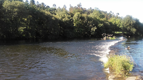
Praia fluvial de Tapia, Ames — local attraction, which is located at A Coruña and belongs to the category — -. Average visitor rating for this place — 4.4 (according to 586 ratings, information from open sources and relevant for 2022).
Exact location — Praia fluvial de Tapia, Ames, marked on the map with a red marker.
You can get directions to Praia fluvial de Tapia, Ames on the map from your location.
What else is interesting in Ames? You can see all the sights if you go to the city page.
Coordinates
Praia fluvial de Tapia, Ames, Spain coordinates in decimal format: latitude — 42.929114741749125, longitude — -8.65855911076157. When converted to degrees, minutes, seconds Praia fluvial de Tapia, Ames has the following coordinates: 42°55′44.81 north latitude and -8°39′30.81 east longitude.
Nearby cities
The largest cities that are located nearby:
- A Coruña — 54 km
- Vigo — 74 km
- Ourense — 90 km
- Braga
 (Portugal) — 151 km
 - Porto (Portugal) — 193 km
- Oviedo — 231 km
- Gijón — 250 km
- León — 254 km
- Coimbra (Portugal) — 299 km
- Salamanca — 329 km
- Valladolid — 353 km
- Santander — 394 km
- Burgos — 410 km
- Amadora (Portugal) — 461 km
- Queluz (Portugal) — 461 km
- Bilbao — 463 km
- Lisbon (Portugal) — 464 km
- Badajoz — 468 km
- Vitoria-Gasteiz — 484 km
Distance to the capital
Distance to the capital (Madrid) is about — 497 km.