
 Belém
Maranguape
Paranaguá
Paranaguá
Monte Alegre
Alvorada de Minas
Bragança
Laguna
Ibiporã
Belém
Maranguape
Paranaguá
Paranaguá
Monte Alegre
Alvorada de Minas
Bragança
Laguna
Ibiporã
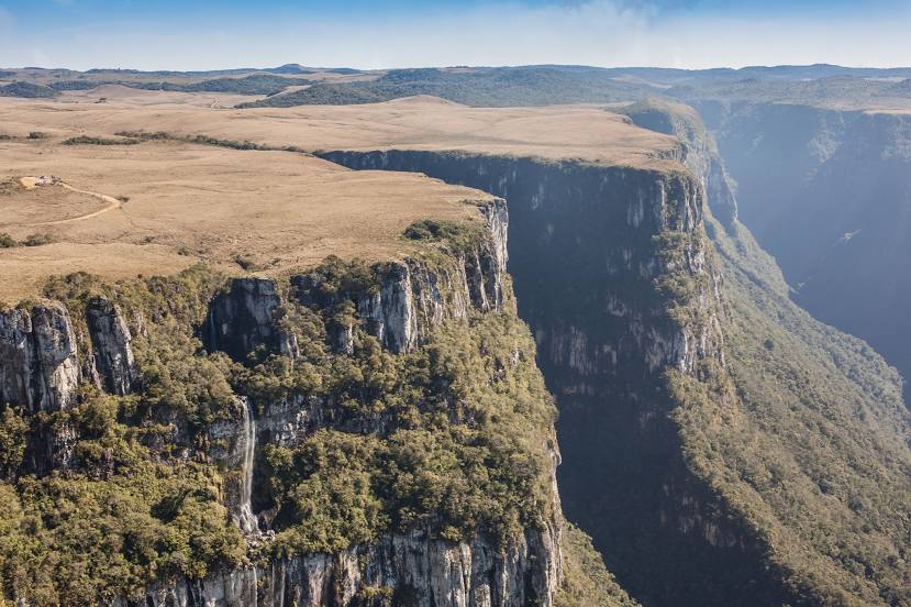
Serra Geral National Park on the map, Jacinto Machado, Brazil
Photo
Where is located Serra Geral National Park
Serra Geral National Park — local attraction, which is located at Rodovia Rs 429, Km 18 s/n Zona Rural, Cambará do Sul - RS, 95480-000, Brazil and belongs to the category — national park. Average visitor rating for this place — 4.8 (according to 2013 ratings, information from open sources and relevant for 2022).
Exact location — Serra Geral National Park, marked on the map with a red marker.
You can get directions to Serra Geral National Park on the map from your location.
What else is interesting in Jacinto Machado? You can see all the sights if you go to the city page.
Coordinates
Serra Geral National Park, Brazil coordinates in decimal format: latitude — -29.140052525880122, longitude — -50.04055428812516. When converted to degrees, minutes, seconds Serra Geral National Park has the following coordinates: -29°8′24.19 north latitude and -50°2′26 east longitude.
Nearby cities
The largest cities that are located nearby:
- Criciúma — 52 km
- Caxias do Sul — 138 km
- Lages — 142 km
- Novo Hamburgo — 152 km
- Gravataí — 157 km
- São Leopoldo — 157 km
- Cachoeirinha — 166 km
- Viamão — 170 km
- Canoas — 170 km
- Porto Alegre — 180 km
- Palhoça — 184 km
- São José — 189 km
- Guaíba — 193 km
- Florianópolis — 196 km
- Blumenau — 240 km
- Itajaí — 255 km
- Santa Cruz do Sul — 269 km
- Passo Fundo — 271 km
- Jaraguá do Sul — 287 km