
 Litoral Del Bajo San Juan
El Cantón de San Pablo
Juan Frío
Santa Barbara
El Juncal
Dibulla
Vereda Campo Alegre
San Pablo
Guaramito
Litoral Del Bajo San Juan
El Cantón de San Pablo
Juan Frío
Santa Barbara
El Juncal
Dibulla
Vereda Campo Alegre
San Pablo
Guaramito
Orellana Park (Parque Orellana) on the map, Leticia, Colombia
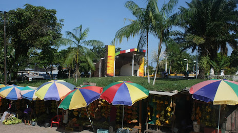
Photo
Where is located Orellana Park (Parque Orellana)
Orellana Park (Parque Orellana) — local attraction, which is located at Cl. 8 #11-1 #11-251 a, Leticia, Amazonas, Colombia and belongs to the category — park. Average visitor rating for this place — 4.0 (according to 525 ratings, information from open sources and relevant for 2022).
Exact location — Orellana Park (Parque Orellana), marked on the map with a red marker.
You can get directions to Orellana Park (Parque Orellana) on the map from your location.
What else is interesting in Leticia? You can see all the sights if you go to the city page.
Coordinates
Orellana Park (Parque Orellana), Colombia coordinates in decimal format: latitude — -4.216316046032415, longitude — -69.94322047568997. When converted to degrees, minutes, seconds Orellana Park (Parque Orellana) has the following coordinates: -4°12′58.74 north latitude and -69°56′35.59 east longitude.
Nearby cities
The largest cities that are located nearby:
- Iquitos
 (Peru) — 369 km
 - White River
 (Brazil) — 677 km
 - Pucallpa (Peru) — 687 km
- Porto Velho (Brazil) — 830 km
- Florencia — 899 km
- Huanuco (Peru) — 933 km
- Neiva — 986 km
- Cajamarca (Peru) — 995 km
- Riobamba
 (Ecuador) — 1004 km
 - Villavicencio — 1009 km
- Pasto — 1009 km
- Cuenca (Ecuador) — 1012 km
- Ambato (Ecuador) — 1014 km
- Loja (Ecuador) — 1022 km
- Santiago (Ecuador) — 1032 km
- Ibarra (Ecuador) — 1037 km
- Huancayo (Peru) — 1039 km
- Popayán — 1041 km
- Quito (Ecuador) — 1043 km
Distance to the capital
Distance to the capital (Bogota) is about — 1083 km.