 Warner Robins
Wantagh
Bethel
Misty Hill Farm
United States
Wakonda Beach (R33) Airport
Wilmington
Poland
Miami International Airport
Warner Robins
Wantagh
Bethel
Misty Hill Farm
United States
Wakonda Beach (R33) Airport
Wilmington
Poland
Miami International Airport
The Landing—Minnesota River Heritage Park on the map, Shakopee, United States
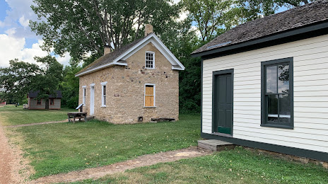
Photo
Where is located The Landing—Minnesota River Heritage Park
The Landing—Minnesota River Heritage Park — local attraction, which is located at 2187 County Rd 101, Shakopee, MN 55379, United States and belongs to the category — park. Average visitor rating for this place — 4.6 (according to 76 ratings, information from open sources and relevant for 2022).
Exact location — The Landing—Minnesota River Heritage Park, marked on the map with a red marker.
You can get directions to The Landing—Minnesota River Heritage Park on the map from your location.
What else is interesting in Shakopee? You can see all the sights if you go to the city page.
Coordinates
The Landing—Minnesota River Heritage Park, United States coordinates in decimal format: latitude — 44.8053257243654, longitude — -93.48636327491506. When converted to degrees, minutes, seconds The Landing—Minnesota River Heritage Park has the following coordinates: 44°48′19.17 north latitude and -93°29′10.91 east longitude.
Nearby cities
The largest cities that are located nearby:
- Minneapolis — 29 km
- Saint Paul — 38 km
- Sioux Falls — 292 km
- Des Moines — 354 km
- Madison — 384 km
- Green Bay — 435 km
- Omaha — 442 km
- Rockford — 458 km
- Milwaukee — 494 km
- Lincoln — 512 km
- Aurora — 545 km
- Naperville — 557 km
- Peoria — 561 km
- Joliet — 578 km
- Chicago — 583 km
- Winnipeg
 (Canada) — 620 km
 - North Kansas City — 632 km
- Independence — 635 km
- Kansas City — 636 km
Distance to the capital
Distance to the capital (Washington) is about — 1509 km.